Florida Coastal Everglades (FCE LTER)
Daniel L. Childers
Associate Professor and Lead Principal Investigator Southeast Environmental Research Center and Department of Biological Sciences
Florida International University, Miami, FL
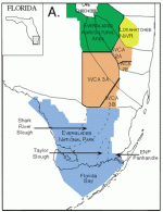
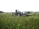
Estuaries and coastal landscapes experience a range of stresses, both natural and man-induced. Among these, cultural eutrophication affects most U.S. coastal ecosystems. Cultural eutrophication is defined as nutrient-enrichment of an ecosystem by human influences. As a result, most coastal ecological research in the U.S. has been conducted in systems that are experiencing eutrophication. In the new Florida Coastal Everglades LTER project (FCE), which was recently funded by the National Science Foundation, we will be investigate how variability in regional climate, freshwater inputs, and disturbance affect land-margin ecosystems (Figure 1). Our research is entirely focused on Everglades National Park (Figure 2). More specifically, we will be quantifying long-term regional controls of population and ecosystem dynamics in an oligotrophic (low nutrient) wetland-dominated coastal landscape. The scientific team that will conduct this long-term research is made up of over 15 research scientists:
- From several departments at Florida International University
- From several other universities around the country
- From both state and federal agencies (including the South Florida Water Management District and the Biological Resources Division of the U.S. Geological Survey)
The coastal Everglades is a particularly appropriate system for long-term research of this kind for several reasons:
- The entire system is oligotrophic--very low in nutrients--and phosphorus is the limiting nutrient
- The south Florida climate is quite variable from year to year, to the point that the difference between rainfall in wet and dry years is nearly as large as the average annual rainfall
- The Everglades is the focus of the largest watershed restoration effort ever implemented, and this restoration will dramatically change the timing and amount of freshwater being put into the system (Figure 3)
- A number of large and diverse datasets already exist for this system from ongoing research projects.
The guiding hypothesis behind our LTER research is that regional processes mediated by water flow control ecological dynamics at any location within the coastal Everglades landscape. The low-salinity regions of Everglades estuaries are excellent places to test this hypothesis because it is here that fresh water draining from phosphorus-limited Everglades marshes mixes with water from the more nitrogen-limited coastal ocean. In this low salinity (oligohaline) zone of the Shark River Slough estuary, we see a clear increase in ecosystem productivity that we hypothesize is a result of nitrogen being provided by the freshwater Everglades and phosphorus being provided by the Gulf of Mexico via tidal inputs. This oligohaline productivity peak coincides with the region that once supported huge wading bird colonies and rookeries. Interestingly, we do not see this kind of oligohaline productivity peak in the estuaries associated with the Southern Everglades because Florida Bay removes the phosphorus from the Gulf of Mexico before it can reach the low salinity regions.
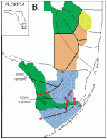
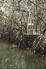
We will be conducting this long-term research along freshwater to marine gradients in two Everglades National Park drainage basins, one through Shark River Slough and one through Taylor Slough and the Southern Everglades, including Florida Bay (Figure 4). Along each transect we will have a number of permanent study sites where we will study a number of ecological parameters. One way to envision this type of transect design is to imagine that we will be following parcels of water as they flow through freshwater marshes and mangrove estuaries to Florida Bay and/or to the Gulf of Mexico. At each station along these transects (Figure 4), we will install automatic samplers that allow us to continuously sample the water flowing past that location (Figures 5 & 6). At each site we will also be quantifying:
- Primary productivity of marsh plants, mangroves, seagrasses, periphyton, and estuarine algae
- The ecological dynamics of organic matter dissolved in the water
- The accumulation or loss of organic matter from soils and sediments
- The ecological dynamics and productivity of fish and aquatic invertebrates
Modelling is a very important component of our coastal Everglades LTER research. We will be using process-based simulation models to link key components, such as the relationships between dissolved organic matter and the microbial processes that can utilize this organic source to drive ecosystem energetics. Our data synthesis will also include hydrologic models to simulate water movement along our experimental transects. The FCE LTER project database will be developed in a Geographic Information System (GIS) that will also integrate these data with information from other related projects. Finally, our GIS database will be linked to a FCE LTER web site to maximize the exchange and dissemination of information within the LTER Network and with the scientific community in general.
 Enlarge this image