The MODIS (Moderate Resolution Imaging Spectroradiometer) sensor aboard NASA's Terra and Aqua satellites provides information about Earth's ecosystem characteristics and dynamics on a near-daily basis. The MODIS sensor acquires data in 36 spectral bands, which are used to produce standardized products, including phenology, land cover, primary production, vegetation characteristics (leaf area index and vegetation indices), radiation, and albedo. However, these products are generally distributed as data files covering a 1200 km square area of the earth in a data format intended for regional analysis and modeling. These large data files are not optimal for use in field investigations at individual sites (100 km x 100 km or smaller).
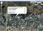
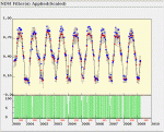
In order to provide MODIS data for field investigations, the Oak Ridge National Laboratory (ORNL) Distributed Active Archive Center (DAAC) has developed a tool that prepares and distributes subsets of selected Land Products (such as leaf area index, photosynthesis, or land cover) in a scale and format useful for field researchers. The subsets are offered in both tabular ASCII format and in Geographic Information System (GIS) compatible GeoTIFF formats. Time series plots and grid visualizations, along with quality assurance indicators, are also provided. An example of this is shown in Figures 1, 2, and 3. These MODIS subsets are produced automatically for more than 1,000 sites across the globe, including sites of the Long Term Ecological Research (LTER) program.
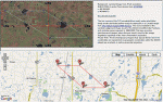
LTER research scientists have collaborated with NASA in the ground validation of NASA data products. The locations of LTER research sites were registered with the ORNL DAAC so that these data are now available to researchers from the beginning of MODIS data acquisition in the year 2000 to the present.
In addition to offering subsets for fixed locations, the ORNL DAAC also offers the capability to create user-defined subsets for any location worldwide. The DACC's MODIS Global subsetting tool provides data subsets from a single pixel up to a 201 km x 201 km area for any user-defined time range. Product statistics, time series plots, and GIS compatible data files for the customized subsets are also distributed through this tool. Users place an order for a MODIS data subset with the subsetting tool online and the subset is typically produced within 60 minutes. An email is sent to the user with the necessary information to access the custom data product.
Users can also use Web Services, a software system designed to support machine-to-machine interaction, to access these MODIS data products. Web Services facilitate data processing directly on the user's local computer, providing access functions to retrieve subsets through command line operations, import them into software such as Kepler or Matlab, integrate the data into workflows on their computer, and write custom code to use the subsets for visualization or data reformatting.
More information about the MODIS subsets and tools to access them can be found at the link for "MODIS Subsets for LTER Sites" on the LTER Remote Sensing/GIS webpage (http://www.lternet.edu/technology/ltergis) or directly at the NASA ORNL DAAC site at http://daac.ornl.gov/MODIS
By Robert Cook, Suresh K. Santhana Vannan, & Tammy Beaty, Environmental Sciences Division, ORNL & John Vande Castle, LNO
 Enlarge this image