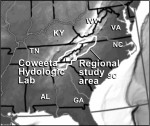
The Coweeta LTER program has expanded both the geographic and programmatic scope of its research. Research sites and topics now span the 70,000 km2 southern Appalachian Mountains region (Figure 1), and include previously ignored historical, social, and economic sciences in our study group. This summary of our activities serves as one example to understanding the social, political, and large-scale natural phenomenon that can not be studied at the organism, plot, watershed, or political boundary scales.
The southern Appalachian region is characterized by steep environmental gradients in temperature, precipitation, and a suite of related biotic and abiotic factors that influence the structure and function of terrestrial and aquatic ecosystems. Superimposed on these naturally occurring gradients are complex patterns of historic (centuries to millennia) and contemporary (decades to centuries) disturbances.
While windthrow, flooding, landslides, drought, insect outbreaks and other natural disturbances occur in the region, humans have long been the primary cause of change in the southern Appalachians. The history of disturbance begins with pre-contact Cherokee, who used fire and low intensity agriculture, increasing with widespread logging and land clearing at the turn of the century, and becoming pervasive with large increases in population and attendant development over the past 20 years (Figure 2)
Although much of this work builds on our 60-plus years of research on ecological processes in terrestrial and aquatic ecosystems in the Coweeta Basin, the new work involves substantially larger spatial and temporal scales than previous studies. Moreover, it explicitly examines the social and economic determinants of human land use decisions, and the physical and biotic consequences of resultant land use patterns.
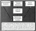
Our research focuses on fundamentally linked components (Figure 3):
- Prehistoric, historic and contemporary patterns of human activity and land use
- Contemporary socioeconomic drivers of land use change
- Effects of land use change on aquatic ecosystems
- Effects of land use change on terrestrial ecosystems.
Regional studies are organized around three main questions:
- How does land-use change interact with natural environmental gradients to control aquatic and terrestrial biological diversity and ecosystem processes in the southern Appalachians?
- How are human decisions regarding land use influenced by social, economic, and ecological factors within the region?
- Can we use our understanding of the linkages among socioeconomic factors, land-use change, and ecosystem structure and function to predict future land-use patterns and their ecological consequences?
While we have three years of progress from studies focused on ecological, historical, and social conditions in the southern Appalachians, we believe our results will have much broader implications. For example, the relationships among land-use changes, exotic species introduction, and biological diversity are major unknowns in ecology, but we have established studies in both terrestrial and aquatic ecosystem to identify these relationships. Work over the last 20 years has caused us to question the assumption that most ecological processes are in dynamic equilibrium. Our studies provide general conclusions regarding how disturbance frequency, life history, demography, and dispersal interact to determine how quickly ecosystems approach predicted equilibrium. Global carbon pools and flux rates are a major uncertainty of widespread importance. Our paleo-, historic, and current records and rate measurements will significantly reduce this uncertainty in the region, and we are developing and testing methods, models, and estimates which should be globally applicable.
Prehistoric, Historic, and Contemporary Patterns of Disturbance and Land Use
Linking ecosystem function with land- use change requires an accurate, quantitative record of the patterns of land use and land cover. Uncertainty regarding the legacies of past land use has limited our ability to explain the structure and function of present-day ecosystems. During the past two years, we developed a 50-year record (hereafter, the "historic" record) of land- cover change for our 70,000 km2 study area, based on aerial photographs (1950s) and satellite data (1970s and 1990s). This data set integrates many key aspects of the regionalization research. These data have facilitated coordinated site selection for the terrestrial and aquatic field studies and thus, are a critical link in the integration of our research program.
Initial analyses of the time series of land-cover change revealed some surprises about the location, extent and shape of recent human activities on the landscape. Although logging peaked ca. 1915 and agricultural activities peaked in the 1930s, nearly 50 percent of the land area of some counties remained cleared in the 1950s. Forest cover and urban/suburban land covers have replaced agriculture during the subsequent four decades, although the rate and extent of this change varies across the region.
When the pattern of all forest cover is examined, including those substantially forested areas with embedded housing, forest fragmentation clearly has decreased in the region. However, when only undisturbed forests are considered, forest fragmentation has increased in many areas. Urban/suburban development has more than kept pace with agricultural abandonment, leading to a net loss of continuous undisturbed forest.
In addition to analysis of the historic record, we have extended our observations further back in time based on sediment sampling. We have inferred cultural and climate effects on fire and vegetation over the last few millennia using sediment charcoal, 210Pb, and pollen data from 10 sites in the southern Appalachians. Results show that fire and vegetation are extremely variable across the range of elevation, topographic, and vegetation settings represented in our data set. We are concurrently integrating our southern Appalachians results within a continental data set of past fire importance.
Socioeconomic Research
Our time-series data clearly demonstrate that patterns of land cover have changed in the Southern Appalachians during the past 40 years, but explaining these changes requires new integrative approaches that include understanding derived from both the natural and social sciences. Physical attributes (e.g., vegetation, elevation, slope) and social variables (e.g., markets, cultural attitudes) all contribute to human land-use decisions and thus to landscape patterns, yet understanding how these many variables interact remains incomplete. We have developed new models that
- Address changes in land use rather than only land cover, as has been done previously
- Incorporate market effects for agricultural and forest products on land-use decisions
- Examine a longer time frame (our 1950 to 1990 period) than has previously been analyzed
Discrete land-use choice models developed for the Little Tennessee River Basin show market factors have significantly influenced land use choices. Models also indicate that the relationships between market factors, site physical variables, and land-use choices have shifted substantially since the 1950s. Expanding on these studies, more sophisticated economic-based land-use models have been constructed for a number of counties. These models extended definitions of land use by including a measure of human occupancy using building densities and by applying measures of forecast performance based on information theory. Topography and road networks direct population diffusion and intensive land use toward riparian areas. This model also has been used to predict future land use, 40 years hence. Current conditions are incorporated to develop site-specific probability maps for each possible land use. These predictions provide a spatially explicit estimate of future human disturbance, at an identifiable level of statistical confidence. Predictions may help
- To identify regions or areas most likely to receive greatest future impacts
- To model related impacts of future land use change (e.g., regional carbon flux)
- To design sampling schemes for fieldwork to test related hypotheses regarding ecosystem and community function
Critical to recent change in Southern Appalachian society is a substantial influx of retirees to the region: North Carolina, Virginia and Georgia are currently ranked nationally as the 5th, 9th and 10th destination for retirees based on population movement. Individuals over 65 years of age are concentrated in certain areas of western North Carolina where greater than 20 percent of the resident population is over 65 years of age. Individuals in this age group tend to locate near amenities, most notably good hospital care, cultural events, and recreational opportunities. These and other factors provide essential context for understanding how people have interacted with land and resources and the potential for change in these interactions.
Collaboration with the terrestrial and aquatic research groups is essential to tie socioeconomic factors to land-use change. Forecasts of land-use change will be used as the basis for generating land-use change hazard maps. By overlaying boundaries of stream catchments we will identify which drainages may be most susceptible to change and those which should remain relatively stable over the next several years. These catchment hazard ratings will be used by the aquatic group to augment their stream sampling so that the effects of changes in landscape condition on stream quality can be monitored. The forecasts of land-use change will also be used to
- Examine the effects of increasing residential development on landscape fragmentation and connectivity
- Examine the potential effects of land use changes on carbon storage conditions in the region
Effects of Land-use Change on Aquatic Ecosystems
Both the historical record and socioeconomic analyses identify the greatest human impacts in riparian and other near-stream areas, where farming was more profitable, infrastructure developed, and access easier. However, few studies have linked these changes in land use to their impacts on stream ecosystems, particularly over broad spatial and long temporal scales. In the Little Tennessee (LT) and French Broad (FB) rivers, we are investigating
- The influences of differing past (50 year) and present land-use practices on fishes and invertebrates, and their trophic interactions across a continuum of forest-agriculture-urban landscapes
- How past and current land use affect the future of aquatic ecosystems.
Watersheds historic land use is a more useful indicator than present land use in predicting species diversity, and the magnitude and length of human agricultural disturbance in a watershed limit the recovery of stream biodiversity for many decades. Forested and agricultural streams clearly differed in assemblage composition, with the exception of two streams. Both these forested streams drain watersheds that were nearly half agricultural in 1950 and over 90 percent forested in 1990. Invertebrate and fish assemblages and substrate of these two atypical "forested" streams most closely resemble those observed in agricultural catchments. Reforestation has not resulted in recovery of stream fauna, possibly due to the observed persistence of finer sediments associated with previous farming.
Effects of Land-use Change on Terrestrial Ecosystems
Our work in terrestrial ecosystems focuses on the interactions among environmental gradients, disturbance, and land-use patterns, and how these interactions influence the diversity and population dynamics of terrestrial species and ecosystem C cycling. Understanding effects of land use on terrestrial animal and plant populations is highly relevant in the southern Appalachians, as the region supports some of the highest biological diversity in North America and is undergoing significant changes in land-use patterns. Similarly, our focus on ecosystem C balance in a diverse and changing landscape will elucidate the significance of forests for C storage, and whether historical, present, and future land-use patterns (driven by socioeconomic and environmental factors) will increase or decrease C storage in the region.
Land-use change often results in habitat loss and fragmentation, with numerous habitat patches that are isolated and reduced in size. In addition, even after human land-use ceases (e.g., cropland is abandoned) and succession again increases habitat connectivity, the effects of past land use on vegetation and soils may persist for decades. We have completed several studies on how land use and habitat fragmentation affects herbaceous species diversity and abundance in cove forests (mid-elevation mesic). We are currently extending these analyses to macroarthropods and herpetofauna.
For more information, please see the Coweeta web page: http://coweeta.ecology.uga.edu/
 Enlarge this image