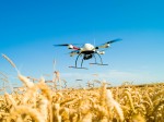
Scientists of the Long Term Ecological Research (LTER) Network are always quick to adopt new technologies that make ecological research fast, efficient, and accurate. Such technology ranges from commercially developed wireless sensor networks that stream remotely sensed data to their desktops or labs, to internally developed cutting edge computer programs such as PASTA. Now, a number of LTER researchers are embracing Unmanned Aerial Vehicles (UAVs)—known to many in the US as “drones” and popular as an effective counter-terrorism technology—to assist with ecological research. The following article describes how two pioneering LTER sites use UAVs for peaceful research purposes.
UAVs for rangeland ecology
The Jornada Experimental Range LTER has been using UAVs since 2006 for rangeland monitoring and other natural resource applications. The UAV program was originally intended to develop techniques for assisting operational land management agencies in their surveys of rangeland conditions, and, especially rangeland health. The resolution of UAV images obtained with consumer grade digital cameras, approximately 6 cm when flying at an altitude of 215 meters, is excellent for determining gaps between vegetation, size of vegetation patches, eroded areas, and the extent of vegetation cover and bare soil. Both the consumer grade digital cameras and a 6-band multispectral camera (which has a resolution of about 13 cm) can be used to delineate vegetation types by species.
Jornada’s first UAV was the Bat 3 made by the MLB Co. and more recently the larger Bat 4 which can carry a larger sensor payload. The Bat 3 weighs 10 kg and has a 1.8 m wingspan, whereas the Bat 4 weighs 45 kg with a 4.0 m wingspan. Using the Bat 4 has increased our payload capacity from 1.4 kg to 14 kg.
Kellogg LTER to fly “drones”
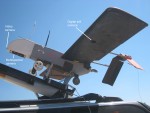
But Jornada is not the only LTER program operating UAVs. In summer 2013, the Kellogg Biological Station (KBS) applied to the Federal Aviation Administration (FAA) for permission to operate a small UAV for research purposes. The KBS aircraft is an md4-1000 helicopter with four rotors measuring just over a meter from rotor shaft to rotor shaft. The aircraft carries a high-resolution radiometer, thermal camera, and a laser scanner that takes centimeter-precise measurements from the air.
KBS's UAV will be used by scientists and PhD students in the crop modeling and UAV lab at the Michigan State University under Bruno Basso (KBS). The decision to use UAV stemmed from the need to improve the quality of remotely sensed imagery. It does this by collecting images with the infrared thermal camera, hyperspectral radiometer, and laser scanner to measure nitrogen and water status in plants, as well as plant heights during different growth stages of the crops.
The craft will be used largely around the KBS LTER site in Hickory Corners in Barry County, primarily to detect spatial variability of crop growth across fields during the growing season and to link this information to a crop model to analyze crop yield and environmental impact of the current management strategies over time and geographic space.
Scientists believe UAVs are well suited for surveys because they result in fewer disturbances to the environment, including the plants and animals being studied. The UAVs’ Global Positioning Satellite (GPS) capabilities allow autonomous revisits to previous study sites to assess rangeland health and changes over time of vegetation type. Other applications using the UAV images with the resolution range of 6-13 cm include precision agriculture including applications of seeds, fertilizer, and pesticides, decision support, forest condition assessment and wildfire monitoring, detailed watershed modeling, archaeological mapping, and production of fine resolution digital elevation models from the UAV stereo images.
UAVs have also been used to monitor rare plants, invasive vegetation species, weeds, algal blooms, phenological cycles of specific plants, as well as migratory birds, seals, sea lions, salmon, and rabbits.
KBS’s UAV can cover 50 acres in about 20 minutes and gather all sorts of information that researchers (or farmers) can use to pinpoint problems and target their responses. For example, fertilizer can be applied exactly where it is needed rather than spread on an entire field.
The technology is relatively cheap (the KBS craft cost about $70,000) and effective in gathering fairly straightforward and objective information such as plant height, temperature, and hydration. An alternative such as remote sensing from a satellite costs a lot more and can be even less effective on a cloudy day.
FAA approval
In order to fly the UAVs in the FAA National Airspace System (NAS), the Jornada established an UAV Flight Crew that required FAA approved training very similar to that required for obtaining a manned pilot’s license. In fact, two members of our Flight Crew were able to qualify and obtain the manned pilot license. In addition to the NAS there is another type of airspace, namely, Restricted Military Airspace (RMA), located primarily in the western U.S. Fortunately, for developing flying flexibility and experience, the 783 km2 area of Jornada is approximately half in RMA and half in NAS. The Jornada Flight Crew is well versed in flying in either type of airspace.
When applying to FAA for approval to fly in NAS, it is required that a Certificate of Authorization(COA) be submitted for approval 3-4 months ahead of the time of the beginning of the proposed experiment. In the U.S., the UAV used must be owned by a public government entity and members of the flight crew must have evidence of having taken and passed the FAA required courses and physical exams.
Once approved, the terms of the COA must be adhered to by the flight crew. The COA can be renewed after one year. In the western U.S. the likelihood of obtaining an approved COA is greater than the eastern U.S. because of lower population densities, less air traffic, and fewer congested airports.
To date, Jornada has acquired COAs over parts of Idaho and Arizona and have flown in southern New Mexico under the New Mexico State University Flight Test Center COA. We have also flown in the RMA of White Sands Missile Range. Flying in various states and two airspace systems has resulted in the acquisition of over 90,000 UAV images. The program has also developed inhouse techniques of orthorectification and mosaicking (i.e., creating mosaics from smaller UAV images, which are just 213 m x 160 m) of the individual UAV images to provide contiguous scenes of the study areas, which are much larger.
Because the final FAA regulations used to integrate UAVs in the National Airspace System are not yet clear, researchers will have to be creative in adapting to the interim regulations and to the final regulations when they are in place. For example, Jornada has developed a method that accounts for the need to keep the UAV within line-of-sight of the external pilot, a FAA requirement, and at the same time moves the external pilot across the landscape at the same pace as the UAV is progressing over the land.
UAVs are very powerful in detecting variability in different areas of a crop field, but their values will be fully exploited when linked to spatial crop modeling to identify best management strategy over space and time. However, the KBS craft has not been used in field experiment yet, as it has taken a long time to get the COA from FAA. All said, however, it appears that the future of the use of UAVs for civil applications is very positive.
 Enlarge this image