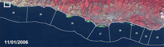
Figure 1: (upper panel) SPOT-5 false color imagery overlain by classified kelp cover (green) for the mainland coast of the SBC-LTER spanning from Arroyo Quemado (AQ) in the west (highlighted box) to the city of Santa Barbara in the east. Image is from November 11, 2006. California Department of Fish and Game (CDFG) administrative kelp bed delineations are also shown as the numbered polygons.
Figure 1: SPOT-5 false color imagery overlain by classified kelp cover
Post date:
Nov 22, 2007