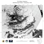
from an NSF press release (14 September 1999)
Surveillance satellite images of the Antarctic Dry Valleys were made public recently by President Clinton, who said the National Imagery and Mapping Agency (NIMA) would make the satellite images available to scientists. Vice President Gore has been working for many years to open U.S. intelligence image archives for scientific use. The release of the Dry Valleys images and a previous release of satellite images from the Arctic Ocean are milestones in the process.
The NIMA image set includes a wide-angle snapshot, taken by surveillance satellites in 1975.
"The data provide a uniform image over the entire region at a single instant, as context for a wide range of studies on the ecology, hydrology, geology, and glaciology of the region," said an NSF spokesperson. To access the high-resolution declassified images, see: http://www.nsf.gov/od/opp/ antarctic/imageset/satellite/start.htm
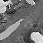
 Enlarge this image