Georgia Coastal Ecosystem
J. T. Hollibaugh and S. J. Pennings, Lead Principal Investigators
M. Alber, J. O. Blanton, D. A. Bronk, W.-J. Cai, A. G. Chalmers, C. B. Craft, D. Di Iorio, L. A. Donovan, R. E. Hodson, S. B. Joye, G. Lin, M. A. Moran, S. Y. Newell, C. Ruppel, and R. G. Wiegert, Co-Principal Investigators
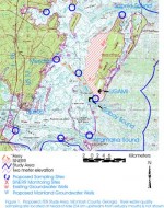
A group of scientists from the University of Georgia, the UGA Marine Institute, Georgia Institute of Technology, Skidaway Institute of Oceanography and Indiana University are gearing up to join the LTER network as the Georgia Coastal Ecosystems LTER. The study site, a barrier island and marsh complex, is located on the central Georgia coast in the vicinity of Sapelo Island and the Altamaha River, one of the largest and least developed rivers on the east coast of the US. The group will investigate the linkages between local and distant upland areas mediated by water - surface water and ground water - delivery to the coastal zone, examining the relationship between variability in environmental factors driven by river flow, primarily salinity, and ecosystem processes and structure.
The upland-estuarine interface of the study area consists of
- The riverine estuary of the Altamaha River
- The lagoonal estuaries bordering the mainland and Sapelo Island
- The tidal marsh complexes fringing small hammocks distributed throughout the coastal area
The salinity regimes of these estuaries result from the interaction of river discharge and ocean tides. The lagoonal estuaries adjacent to upland areas are also influenced, though to a lesser and more localized extent, by local surface runoff and groundwater seepage directly to the marsh.
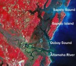
The most southerly estuary is Altamaha Sound, which lies at the mouth of the Altamaha River, the largest river in Georgia. Altamaha Sound is strongly river-dominated and constitutes a complex delta made up of low islands, marshes and tributaries. Doboy Sound, located to the north of Altamaha Sound, connects to the coastal ocean via a pass between Sapelo Island and the marsh complexes of Wolf/Queen Islands. Freshwater from the Altamaha River is transported into upper Doboy Sound through the connecting Intercoastal Waterway and marsh channels. Tidal exchange with the Altamaha’s plume in the coastal ocean can also deliver low salinity water to Doboy Sound. Thus, mixing with sea water occurs under most conditions, so that water reaching Doboy Sound has low salinity but is not fresh. The third estuary, Sapelo Sound, is at the northern edge of the study area. Like Doboy Sound, it is a lagoonal estuary with no large streams discharging directly into it. Fresh water enters as precipitation, groundwater or as small volumes of surface inflow.
The new LTER will take advantage of the long term record of scientific study and ecosystem preservation that have been established by the University of Georgia Marine Institute (UGAMI) on Sapelo Island and the Sapelo Island National Estuarine Research Reserve (SINERR). Additionally, the Georgia Rivers LMER (GARLMER), which is concluding in October 2000, examined processing of materials transported through the intertidal zone of the Altamaha River and of four other Georgia coastal rivers. UGAMI studies of the Sapelo Island marshes began in 1954 and have resulted in over 800 publications. These publications, GARLMER data, long-term SINERR monitoring records, and aerial photographs dating back to 1953 provide a perspective on long-term changes in the system and will help in interpreting data collected during the LTER project.
A general organizing principle of this study is that the structure and function of coastal ecosystems is affected by the variability of an environmental factor (e.g., salinity) as well as by the mean value experienced at a given location. The hierarchy of spatial and temporal variation produces a cascade of ecological effects across multiple scales. At time scales spanning the range from hourly to annual, and spatial scales ranging from um to km, coastal ecosystems are influenced by both natural and anthropogenic perturbations (physical and chemical) that affect both the variability and the mean of important ecosystem properties (for example, hurricanes or flood control projects alter river hydrographs, which in turn affect sediment distributions and transport, estuarine salinity, etc.). We postulate that the scales of detectable change in ecosystems and associated physical and chemical systems indicate the scales of the most critical forcing. We propose to use the existing gradient (mean and variability) of one important variable, salinity, to separate the effects of different means from the effects of different variances for key ecosystem properties with inherent spatial and temporal scales ranging from um to km and minutes to years.
Field studies will focus on hydrodynamics and hydrology, assessment of ground water inputs, and the relationship of flows and fluxes to morphology. Complementary studies will include DIC, O2 and NO3 fluxes, sediment biogeochemistry, and plant, animal, and microbial community composition, density and diversity. Specific processes that will be addressed by field studies and numerical simulations include:
- Influence of hydrological processes (evaporation, transpiration, groundwater input, marsh circulation) on the salt balance at different places in the creek-marsh complex
- Angiosperm production, community structure and population genetics
- The interactions of prokaryotes and eukaryotes in marsh grass decomposition. Evidence suggests that both fungi and bacteria play critical roles in decomposition in the intertidal marshes of the Georgia coast, and that fungal processing of standing-decaying marsh grass is key to the transfer of this material to animals.
The impacts of human activities in the watershed are an important component of the long term variation we expect to detect in this study. The coastline of Georgia is currently among the least developed in the United States, but is projected to see rapid urbanization over the next few decades. The headwater tributaries of the Altamaha River drain much of central Georgia, including an area of southeast Atlanta, which currently has one of the highest population growth rates in the US. At the same time, coastal Georgia is also experiencing growth. The study area currently has low population density, but the urbanization and growth that characterize Savannah to the north and Brunswick to the south are beginning along the I-95 corridor in McIntosh County, with development of coastal waterfront property proceeding rapidly as well. Models and related studies of the impact of land use change on salinity distributions within the Altamaha estuary, freshwater runoff and river discharge were begun in GARLMER and with funding from the Georgia Coastal Zone Management Program. As part of the LTER, we will expand these studies to include the effects of land use changes on river water quality.
 Enlarge this image