The LTER Network Office (LNO) is coordinating access by LTER sites to historical and recent satellite reconnaissance data, as well as MODIS time series subsets and imagery from the International Space Station. This effort is to provide access for LTER sites to data that are acquired and archived by collaborating partners, including the National Aeronautics and Space Administration (NASA) and the United States Geological Survey (USGS). Information on these and other LTER Network remote sensing data is available on the LTER remote sensing and GIS information page at www.lternet.edu/technology/ltergis/.
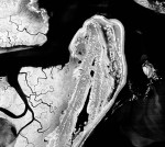
GFL Reconnaissance imagery of LTER Sites
The Global Fiducial Program and its “library,” the Global Fiducial Library (GFL), resulted from a National Research Council (NRC) panel recommendation for the collection of data from a global network of fiducial sites as a tool to address global issues such as sea-level change, tectonic plate movements, and other global change issues. The full recommendations are summarized in the NRC committee’s report, “International Network of Global Fiducial Stations: Science and Implementation Issues,” published in 1991. With the approval of the LTER Coordinating Committee in 1996, the LNO has worked with the USGS to register all LTER sites as GFL targets and to enable operational collection of GFL data from current reconnaissance satellites. In 2002, the government declassified raw imagery from older intelligence satellites and transferred the rolls of film to the National Archives and the USGS EROS Data Center. The data provided high-resolution imagery from 1959 to 1980, in some cases greater than 1 meter. Although the historic data are publicly available, the operational acquisition of data from currently classified systems will capture this record for retrospective analyses as part of the GFL archive. Access to these current data requires proper security clearance, although the data will eventually be declassified for public use. Further background information and examples of declassified data acquired for some LTER sites is available at www.lternet.edu/technology/gfl/.
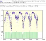
Data from the MODIS sensor of the Terra and Aqua satellites
Time series subsets of MODIS data provide summaries of selected MODIS land products to validate models and remote sensing products, and to characterize LTER field sites. These data include leaf area index and fraction of photosynthetically absorbed radiation (LAI/fPAR), land cover, normalized difference vegetation index and enhanced vegetation index (NDVI/EVI), gross primary productivity (GPP), net primary productivity (NPP), surface reflectance, and land surface temperature. The data are available as part of an ongoing collaboration between LTER and the National Aeronautics and Space Administration’s (NASA) Distributed Active Archive Center (DAAC) at the Oak Ridge National Laboratory. The MODIS data subsets were initially extracted from the MODIS data archive for LTER sites that have active NASA validation research projects. Information for these time series products was recently updated to include data from at least one 7 km x 7 km area at all LTER sites.
These MODIS subsets will be available as the data are reprocessed during 2006. Specific site locations can be viewed most easily using the DAAC map services viewer: webmap.ornl.gov/mascol5/viewer.htm. The DAAC has also developed a subsetting and visualization tool that can generate MODIS subsets for any North American location. Subset data can be extracted from areas of 1 km x 1 km to 201 km x 201 km, and for a user-selected time period of the complete MODIS record. These data can be accessed directly at www.modis.ornl.gov/modis/NorthAmerica_Tool/. For more information on the MODIS subset data visit www.lternet.edu/technology/nasa/modis/.
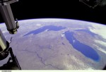
International Space Station Imagery for LTER Sites
The LNO and NASA’s Johnson Space Center (JSFC) are working on the potential use of International Space Station (ISS) photography for LTER Sites. The ISS imagery is a uniquely useful dataset for the LTER Network as it varies greatly in spatial scale and temporal frequency (i.e., geographical scope and how often the data are collected). Used with traditional remotely-sensed data, ISS imagery can increase the temporal resolution of observed variables such as land cover, land use change, vegetation dynamics, and surface soil processes. The data can also capture extreme events such as fires and hurricanes to supplement data from other sources. A search of the ISS archive revealed hundreds of images of some LTER sites captured during past missions.
William Stefanov, a JSFC scientist who formerly worked at the Central Arizona-Phoenix LTER site was instrumental in getting JSFC to add LTER sites as specific targets for ISS missions. With Stefanov’s help, LTER submitted to JSFC a science plan requesting acquisition of nadir digital imagery with less than 10 percent cloud cover to capture spring, summer, fall, and winter seasonal changes in vegetation. The science plan has been followed by ISS missions since the ISS 011 crew. Since image resolution depends on the lens used, the plan specifies both wide angle lenses for general site mapping and telephoto lenses to capture details such as tree-shrub-grassland transitional areas. Arctic and Antarctic LTER sites are not included in these data due to the ISS’s orbital characteristics, but data are available for most other LTER sites.
More information on this collaboration can be found at www.lternet.edu/technology/nasa/iss/. The ISS imagery is freely available online at http://eol.jsc.nasa.gov/.
 Enlarge this image