Doug Schaefer, Institute for Tropical Ecosystem Studies, University of Puerto Rico, and William McDowell, Department of Natural Resources, University of New Hampshire.
Until satellite images made it obvious, we could not be completely certain that hazy skies in Puerto Rico meant that dust was blowing in from Africa. But now this source of chemicals in rain, and several others as well, have been identified by LTER research. Potential linkages between rain chemistry and climate have also been uncovered
History
Scientists at the Luquillo LTER in Puerto Rico have measured rain chemistry almost every week since 1985 as part of the National Atmospheric Deposition Program (NADP--see the WWW site: http://nadp.sws.uiuc.edu). Hurricane Hugo blew down the sampling tower in 1989, but it was rebuilt and several more recent hurricanes have been successfully sampled. The initial 48 months of data were presented by McDowell et al. (1990), and Schaefer and McDowell are now preparing a manuscript on the entire data set for the journal Atmospheric Environment. This article highlights the main points of that study.
By the Sea
Rain chemistry at LUQ is dominated by marine inputs, with sodium and chloride inputs combined averaging almost 150 kilograms per hectare annually. By comparison, even the coastal U.S. NADP sites receive less than 1/10 that amount, dissolved in 1/3 as much rainwater. Mixing one part seawater with 6000 parts pure water would give a fair approximation of LUQ rain. The marine aerosol is injected into the atmosphere by waves breaking at shore, and by whitecaps when winds over open water exceed 15 knots.
Out of Africa
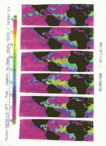
Magnesium and potassium inputs also follow their seawater ratios, but calcium substantially exceeds the amount in sea water. The excess calcium was attributed to trans-Atlantic transport of Sahara dust by McDowell et al. (1990), but direct evidence for the process was lacking. More recently, global atmospheric optical thickness (or AOT, from the scattering of blue light), has been estimated by the National Environmental Satellite, Data and Information Service (NESDIS) on weekly and monthly scales. The results are translated into images, which may be viewed on http://psbsgi1.nesdis.noaa.gov:8080/PSB/EPS/Aerosol/Aerosol.html
These weekly images (Figure 1) clearly show transport and arrival of Sahara dust clouds, and linear regression between AOT and weekly calcium deposition in excess of the sea salt ratio has an R2 of 0.52. The relationship is even stronger when we account for weeks in which there was not enough rain fall to remove all the dust from the air. From these relationships we estimate that 2.7 kilograms per hectare (or about 60%) of the calcium in LUQ rain comes from the Sahara desert. In the continental U.S., only Midwestern farming areas receive this much calcium in rain, which comes from local sources in those areas.
Sahara dust reaches the Caribbean from June through September, but the emission season begins earlier. One of the larger events occurred in February 2000, and was pictured in the September 2000 issue of National Geographic magazine. Dust from the early-season events is washed out of the atmosphere by rain falling over the Atlantic Ocean. During the summer, rain over the Atlantic becomes concentrated into a series of tropical waves, and dust aloft in the spaces between the waves is transported further to the west. In any case, most of the Sahara dust ends up in the equatorial Atlantic. While the NADP does not analyze rainwater for iron, Sahara dust is rich in this element (Prospero et al., 1981). Whether this iron stimulates algal growth (and the subsequent uptake of atmospheric carbon dioxide) in the otherwise nutrient-poor surface waters of this part of the Atlantic Ocean has yet to be explored.
Anthropogenic Inputs
The pH of LUQ rain averages 5.3, much less acidic than the pH 4.5 or less falling on the northeastern U.S. Acidity, nitrogen and non-sea salt sulfate deposition at LUQ peak during April and May, when low pressure systems move off of the southeastern U.S. and enter the Caribbean. During other months much less anthropogenic pollution from North America reaches Puerto Rico.
Too Much Sulfate
The sulfate story is somewhat more complicated. NADP stations in the southeastern U.S. receive sulfur and nitrogen in rain at a mass ratio of 2.1 to 1, while the ratio at LUQ (after excluding marine sulfur) is 2.5 to 1. There seems to be an additional source of sulfate in LUQ rain beyond the smokestacks and the sea. Most interestingly, this additional sulfur peaks during July and August when the Atlantic surface waters are warm. Dimethyl sulfide (DMS) emissions from planktonic algae, oxidized to sulfate in the atmosphere, may be the answer but this has not been proven. How can we know for sure? The ratio of the stable isotopes of sulfur (mass 34 and 32) is higher than seawater in fossil fuels, and lower in algal DMS emissions (Brimblecombe and Lein, 1989). Thus we hypothesize that there is a seasonal pattern in sulfur isotope ratios in LUQ rain: high in April and May, low in July and August and at intermediate (sea water) levels in other months.
The Luquillo Experimental Forest has been an LTER site since 1988, and has archived these weekly rainwater samples throughout that time. We did not begin with the intention of analyzing sulfur isotopes in rain by mass spectrometry, but with the archive this hypothesis may now be tested. Its significance may extend well beyond a few kilograms of sufate in rain at LUQ -- sulfate in the atmosphere forms cloud condensation nuclei, and more clouds mean less heating at the Earth’s surface. If algal DMS emissions increase with sea surface temperatures, this could serve as a feedback loop to limit climate extremes.
As an LTER site, scientists at LUQ collect and store the samples, uncover the patterns, and formulate the hypotheses-- illustrating one of the great strengths of long-term ecological research. Call it the research ‘Field of Dreams’ if you like. Find the patterns, and the mechanisms will come.
When the Hurricanes Blow
Finally, what about hurricanes? Even a "near-miss" can cause 0.5 meter of rainfall at LUQ, which averages 3.2 meters per year. Hurricane rain collected at LUQ is 50 percent more concentrated in marine ions than average rain, and very dilute in all the rest. Obviously hurricane winds are well above the 15-knot "speed limit" for marine aerosols. So, if your Caribbean island vacation is spoiled by rain, remember that the sources of its chemicals are varied and far-flung--sea salt, fossil fuel combustion products, desert dusts from across the Atlantic and possibly even marine algal emissions contribute to the chemistry of rain there.
References
Brimblecombe, P. and Lein, A. Yu. (1989) Evolution of the Global Biogeochemical Sulphur Cycle. Wiley, Chichester.
Broeker, W. and Peng T.-H. (1982) Tracers in the Sea. Lamont Doherty Geological Observatory, Palisades, New York.
McDowell, W. H., Gines Sanchez, C., Asbury, C. E. and Ramos Perez, C. R. (1990) Influence of aerosols and long-range transport on precipitation chemistry at El Verde, Puerto Rico. Atmospheric Environment 24, 2813-2821.
Prospero, J. M., Glaccum, R. A. and Nees R. T. 1981. Atmospheric transport of soil dust from Africa to South America. Nature 289, 570-572. Schaefer, D. A. and McDowell, W. H (in prep.) A 13-year record of precipitation chemistry in the Luquillo Experimental Forest of Puerto Rico. For Atmospheric Environment.
 Enlarge this image