Several members of the LTER Network information management team recently participated in a program dedicated to building regional cooperation among the governments of Egypt, Israel, Jordan, Tunisia, and the Palestinian Authority.
The Cooperative Monitoring Center (CMC) at Sandia National Laboratories in Albuquerque, New Mexico funded the LTER personnel to lead the workshop, which took place 9-15 September 2001 in Bonn, Germany. The participating scientists are involved in the CMC-sponsored "Regional Initiative for Drylands Management" program, which addresses environmental and sustainable production issues related to desertification.
A shorter workshop on Knowledge Management was conducted by the Cooperative Monitoring Center for agency heads. Three of the participants in this workshop had previously attended an LTER Ecoinformatics training held in October 2000 at the Sevilleta. Feedback from the participants indicated that the three graduates of the Ecoinformatics training were clearly the best prepared for the Knowledge Management workshop.
The Ecoinformatics workshop included the following topics:
- Overview of Ecoinformatics (Kristin Vanderbilt-SEV)
- Hardware and Networking Design (David Blankman-NET based on materials developed by James Brunt-NET)
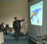
- Remote Sensing and GIS Concepts and Software (John Vande Castle-NET)
- Web Page Design: HTML and XML Overview (Vanderbilt and Blankman)
- Metadata Concepts and Software Tools, Data Archiving, Data Synthesis (Bill Michener-NET)
John Porter (VCR) was to have taught database modeling and SQL during the last few days of the workshop, but the events of September 11 precluded his trip to Germany. Blankman and Vanderbilt filled in using materials prepared by Porter.
Perhaps the most significant parts of the training were the small discussions on data modeling and barriers to effective data management and collaboration. Not surprisingly, lack of resources -- human and technical -- was a common complaint. More importantly though was the description of a culture of information hoarding. Most of the participants complained about the difficulty of obtaining relevant data. For many of the participants data in any form was scarce. The Israelis said that there was lots of data available, but most of it was in paper form, which made it difficult to use (Vande Castle's Second Rule states "the only real data is digital data").
Often when digital data was available inside a country or even inside an agency, the participants' complained that barriers exist to sharing the data. The barriers came in various forms:
- Financial (we will let you use the data, but it will cost you)
- Proprietary attitudes (our data is ours and we don't want to share it)
- Confidentiality/security concerns (revealing this data might be detrimental to national or ecological interests, e.g. endangered species lists, or water supply data)
- Technical
- a. Data might exist, but no mechanism exists to find out about it
- b. Even when the data was available for sharing, different software protocols made data sharing impractical
It is important to note that these issues were raised when the participants were focused on barriers that existed within their own countries and institutions. These barriers get significantly higher when the context shifts to data sharing between countries. It is ironic that for countries participating in "The Regional Initiative for Drylands Management," water supply data is considered by many to be "classified." This is a region where terrorism was part of life well before September 11.
While the Ecoinformatics training was not able to deal directly with confidentiality and security concerns, the technical barriers were addressed fully. The financial constraints and proprietary attitudes were addressed to a lesser extent. Proprietary attitudes are not, of course, unique to the Middle East. The culture of data sharing, even in the LTER Network, is new and not of primary concern to most researchers in any country. David Betsill, of the Cooperative Monitoring Center, Sandia National Laboratories talked about funding sources and strategies.
The participants’ positions and main interests:
- Imad Al Baba, Senior Researcher and Director of Research and Development, Ministry Of Environmental Affairs, Palestinian Authority, Ecological Database And Wildlife Management
- Zaki Zoarob, Director, Protection Of Environmental Resources, Ministry Of Environmental Affairs, Palestinian Authority
- Mahmoud Al Jaloudi, Head Of Prime Section, Ministry Of Agriculture, Jordan, Forestry And Range Management
- Nvart Taminian, Computer Assistant and Office Administrator, Ministry Of Agriculture, Jordan, Computers Systems Management
- Lilia Ben Abdallah, Responsible for Quality Management, CITET, Tunisia
- Tarek Ben Ali, Director Of Exploitation, ONAS, Tunisia, Treatment Of Waste Water
- Abdelrahman El Shemy, Assistant Research, Agriculture Research Center, Egypt, Soil Science
- Mohamed Sayed Ahmad, System Engineer, Ministry Of Agriculture, Egypt, Remote Sensing
- Regev Manor, Ph.D. Student, Ben-Gurion University, Israel, Biodiversity Conservation
- Lea Orlovsky, Researcher At The Remote Sensing Laboratory, Ben-Gurion University, Israel, Desertification Monitoring By Remote Sensing
During the course of the training, solutions to the technical barriers to data sharing were discussed at length. At many different parts of the training we talked about the importance of supplying metadata, "the more, the better." Bill Michener demonstrated Morpho, a metadata editor and query tool, developed by NCEAS as part of the Knowledge Network for Biocomplexity (KNB), KDI grant. We presented, in conceptual terms, how XML can be used to query multiple databases and transform the data into a common format. A number of different existing data archives were presented, including Metacat, a metadata catalog being developed as part of the KNB. We discussed, briefly, how a Metacat might be useful for the workshop participants and their institutions.
Our ten students reported that they had learned a great deal and would be able to implement portions of what they had been taught. A common theme among the participants was that this training was a good sampler, "this is like a good appetizer, and our appetite is whet for the main course." There was a strong demand for further training, especially in the areas of remote sensing and GIS. The participants' goal is to use technology to build bridges between scientists in the region studying the common issue of desertification, and they felt that this workshop brought them a step closer to cooperation through data sharing.
 Enlarge this image