The Digital Library for Earth System Education (DLESE), with Palmer (PAL) LTER attending, held a Data Services Workshop April 18-20, 2005 to develop an online curriculum for grade 6-12 education.
Since a hallmark of PAL education outreach has always been an interdisciplinary approach to community learning, PAL brought a strong cross curricular team that focused on the use of LTER site long-term data.
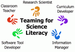
During the workshop, participants worked with DLESE (http://www.dlese.org) members to develop a chapter in the Earth Exploration Toolbook (EET; http://serc.carleton.edu/eet/) by working as interdisciplinary teams drawing upon existing Earth system data sets and information management, data-analysis software development, and expertise in classroom teaching and curriculum development.
PAL’s Schoolyard LTER program was initiated by Karen Baker (PAL Information Manager), informed by the seminal LTER Workshop on Education Project Planning at Biosphere 2 in October 1998 that was led by Diane Ebert-May. Subsequent NSF/DEB Schoolyard grants allowed PAL education outreach to build toward partnerships with nationally coordinated programs such as TERC and DLESE, with which the PAL education team has been working since 2000.
The Spring DLESE workshop and EET project built upon education projects incorporating biome approaches (Berkowitz et al., 2003) and appropriate data availability (Edelson, 1998). The workshop provided an opportunity to explore the development of curricula incorporating data sets from scientific data generating programs (termed “authentic data”) and to use contemporary software analysis tools in classroom science.
The workshop structure offered individuals the option to assemble an interdisciplinary team by joining with others during the workshop. However, Beth Simmons, the Education Coordinator for PAL and California Current Ecosystem, decided to form a team—mainly members of the PAL community—in advance of the workshop, thus tapping into LTER site knowledge about the research, data, and education outreach pertinent to the local data sets being used for the curriculum.
The team considered the experience of a classroom science teacher and curriculum developer as essential to crafting the most age-appropriate and effective online curriculum. Team members also realized that although using new software analysis tools could enhance student learning, such usage required tempering by awareness of the computer resources and the target audience’s prior knowledge.
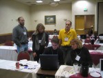
Simmons, a curriculum developer and science educator, headed the team that included (Figure 1) Karen Baker; Alec Barron, science educator at The Preuss School, a charter school for grades 6-12 at the University of California, San Diego; Clay Hamilton (Stanford), an analysis tool developer, graphic designer and earth sciences interpreter; David Smith (Northwestern), the developer of the analysis tool My World (http://www.worldwatcher.northwestern.edu); and Sharon Stammerjohn (Lamont Doherty Earth Observatory), who has a long history with PAL and contributed satellite ice research expertise.
Baker observed that the resulting EET curriculum introduced the overarching theme of response to environmental change by using, first, hands-on work with blood worms exposed to wet/dry conditions and, second, the concept of Adelie penguin population dynamics in the warming environment near Palmer Station.
Simmons, who facilitated the workshop, added, “Our story unfolds by exposing students to temperature and sea-ice concentration data and then guiding them to investigate the influence of these parameters on penguin colonies along the Western Antarctic peninsula.” Simmons and Barron focus on in-classroom assessment of curricula, an essential step in honing the final product (Wiggins, 1998; Ebert-May et al, 2003; Simmons, in press), so the initial version of the curriculum developed by the workshop was tested this Spring in Barron’s sixth grade science class at Preuss. The pair presented the results from this assessment at the PAL Steering Committee meeting held at the Scripps Institution of Oceanography in August 2005. The final version of the curriculum will appear on the SERC/EET website.
References
Berkowitz ARN, Nilon CH, and Hollweg KS. 2003. Understanding Urban Ecosystems: A New Frontier for Science and Education. New York: Springer-Verlag.
Ebert-May D, Batzli J and Lim H. 2003. Disciplinary Research Strategies for Assessment of Learning. Bioscience 53: 1221-28.
Edelson DC. 1998. Realizing Authentic Science Learning through the Adaptations of Scientific Practice, International Handbook of Science Education. In: Tobin K and Fraser B (Eds). International Handbook of Science Education. Dordrecht: Kluwer Academic.
Simmons, B. in press. Assessment, Chapter 6 in Schoolyard LTER Handbook.
Wiggins G. 1998. Educative Assessment: Designing Assessments to Inform and Improve Student Performance. San Francisco: Jossey-Bass.
Relevant Links
DLESE: The Digital Library for Earth System Education provides collections of educational resources, Earth data sets and imagery as well as support services for utilizing these resources in the classroom.
SERC: The Science Education Resource Center, an office of Carleton College, has special expertise in geoscience education, community organization, workshop leadership, digital libraries, and website development. SERC’s Cutting Edge program (see http://serc.Carleton.edu/usingdata/related.html) emphasizes inquiry-based curriculum units using authentic data.
Earth Exploration Toolbook (EET): A collection of computer-based Earth science activities, or chapters, that introduce data sets and analysis tools enabling users to explore Earth system science.
TERC (no longer an acronym, but a noun): A not-for-profit education research and development organization based in Cambridge, Massachusetts with the mission of improving mathematics, science and technology teaching and learning. TERC supports inquiry-based learning.
MyWorld: A classroom Geographic Information System (GIS) tool developed by Daniel Edelson and David Smith within the research education program at Northwestern.
Beth Simmons (Education Outreach Coordinator), Dawn Rawls (Science Writer), and Karen Baker (Information Manager), PAL
 Enlarge this image