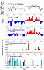
The new California Current Ecosys tem (CCE) LTER site represents a pelagic (i.e., the ocean water column) coastal upwelling biome, as found along the eastern margins of all major ocean basins. These are among the most biologically productive coastal ecosystems in the world. Research at this site will focus on mechanisms leading to transitions over time between different states of the pelagic ecosystem. Observations from the remarkable California Cooperative Oceanic Fisheries Investigations (CalCOFI) coastal ocean time series – currently in its 55th year – demonstrate the effects of external factors in forcing alterations to this ecosystem on multiple time scales. These factors include a warming trend that has been documented over the past 5 decades, the long term warming and cooling cycles (ca. 20-30 years) represented by the Pacific Decadal Oscillation, and the year-to-year temperature fluctuations dominated by El Niño. Combinations of these processes, together with interactions among living organisms, can lead to ecosystem responses that may be manifested as relatively abrupt transitions.
Research Focus
The CCE site proposes to evaluate four hypothesized mechanisms for these kinds of rapid ecosystem transitions:
- Localized food web changes in response to changes in ocean temperature stratification and nutrient supply
- Sustained, irregular alongshore transport of different assemblages of organisms
- Changes in cross-shore transport and loss/retention of organisms
- Altered predation pressure
Our site will address these hypotheses with an integrated research program having three primary elements:
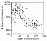
- Experimental Process Studies will initially focus on the hypothesis of localized food web changes in response to changes in water column stratification. Here we will use space as a substitute for time, since many of the temporal changes that are observed in this region have clear spatial analogs. For example, the nitracline depth (depth where nitrate first exceeds 1 µM) deepened dramatically during the 1997-98 El Nino, after which it may have returned to a shallower average depth. At a single point in time we find spatial variations in nitracline depth within our LTER region that encompass these temporal variations. Variations in nitracline depths over this range are associated with changes in composition of the food web’s primary producers, in this case tiny unicellular cyanobacteria, which show highest abundances at intermediate nitracline depths (Fig. 2). We will exploit such spatial differences to develop continuous functions that describe growth and loss rates of different members of the plankton assemblage in relation to nitracline depth. These functions will then be used in our coupled bio-physical models to simulate the ecosystem effects of changes in nitracline depth over time.
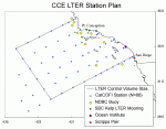
- Time Series Studies will evaluate our alternative hypotheses, using time series measurements from a variety of CCE LTER research stations (Fig. 3). These measurements will include
- A quarterly measurement program at sea that will capitalize on and significantly enhance the CalCOFI time series by also assessing the microbial community, dissolved and particulate organic matter, and iron geochemistry;
- Satellite remote sensing observations, including phytoplankton pigments and sea surface temperature
- Frequent temporal measurements at different nearshore locations through collaborations with coastal observing systems.
- Modeling studies will be an integral part of this site. Models will be used to help interpret and understand the dynamics underlying observations; to provide a platform for hypothesis testing through numerical experiments; and to provide a means for dynamic interpolation between observations in space and time. Three different types of models will be employed: coupled 4-D, eddy-resolving bio-physical models of the California Current ecosystem based on ROMS (the Regional Ocean Modeling System); nonlinear time series hindcast models; and control volume property flux models. Control volume models will enable us to estimate net fluxes of properties such as heat, salt, nutrients, oxygen and phytoplankton biomass through the 3D box defined by the stations and the coast, by assuming that the convergence of mass into the box created by horizontal currents is balanced by upwelling-related divergence of mass out of the box, and solving for the net flux.
These collaborations include the Santa Barbara coastal (SBC) LTER site, the newly developed SCCOOS (Southern California Coastal Ocean Observing System) program, and our Education and Outreach partner, the Ocean Institute.
Information and Outreach
In addition we will advance Information and Data Management to support data and metadata internally, and facilitate the exchange of research findings with other LTER partners, educators, the general public, and policy makers. Our information system will contain multiple layers for storage, access, and discovery, and act as an interface to users, other systems, and analysis packages. Documentation and data storage will be organized through an electronic hub at the Integrative Oceanography Division (IOD) at the Scripps Institution of Oceanography. Our Education and Outreach program will team scientists with California COSEE and three external partners to engage the “K through grey” community in both the process and the understanding gained from this research. We will train undergraduates, graduate students (in collaboration with a Scripps-based IGERT), and postdoctoral scholars across disciplinary boundaries. Through collaborations with informal science education organizations, we expect to reach many K–12 schoolchildren each year, including local low-income and minority students.
Site Location
The CCE site is in the southern sector of the California Current, which is part of the great clockwise circulation pattern of the North Pacific. Our site extends from the major upwelling site at Point Conception to the U.S.-Mexican border, and from the shoreline approximately 500 km offshore. This region lies between ca. 30-35º N and 117-124º W.
Participants in this site come from the Scripps Institution of Oceanography/U.C. San Diego, the Southwest Fisheries Science Center of NMFS/NOAA, Pacific Fisheries Environmental Laboratory, Duke University, Georgia Institute of Technology, and the Point Reyes Bird Observatory.
The proposed study region is an ideal location for an LTER site for many reasons, including:
- Five decades of climate and ecosystem context provided by CalCOFI
- Inclusion of a biogeographic boundary region, making it an early sentinel of climate change
- Pronounced spatial gradients that represent much of the dynamic range of the entire ocean environment
- Anoxic basins that provide a unique connection to paleoceanographic studies
- An existing physical ocean circulation model of the region that will permit rapid advances in the development of coupled bio-physical models relating to ecosystem transitions.
We look forward to working together actively with colleagues in the LTER network to compare coastal pelagic upwelling ecosystems with other biomes, with respect to the five core research themes of LTER as well as other topical issues.
References
Collier, J. L., and B. Palenik. 2003. Phycoerythrin-containing picoplankton in the Southern California Bight. Deep-Sea Research II 50: 2405-2422.
Mantua, N. J., S. R. Hare, Y. Zhang, J. M. Wallace, and R. C. Francis. 1997. A Pacific interdecadal climate oscillation with impacts on salmon production. Bulletin of the American Meteorological Society 78: 1069-1079.
Ohman, M. D., and E. L. Venrick. 2003. CalCOFI in a changing ocean. Oceanography 16: 76-85.
Mark D. Ohman, Lead PI, CCE LTER, Scripps Institution of Oceanography, University of California, San Diego
 Enlarge this image