The first product from the LTERMapS (LTER Map Services), an information portal built on the Google Maps™ API, was recently migrated to the LTER Network Office (LNO) and made available at http://www.lternet.edu/map/. This product was developed by a subset of the Information Managers GIS (Geographic Information Systems) group and represents the first of a two phased approach designed to accommodate both the needs of the general populace as well as those of researchers interested in a more robust system.
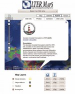
Phase one of LTERMapS provides a valuable information portal that offers a network-wide mapping solution targeted at a broad range of user groups. The Google Map™ is customized to dynamically harvest and display information from the LTER Network’s site database (SiteDB) and to reflect any content changes in real time. For each LTER site a popup balloon shows the site description, contacts, and clickable links for outside resources. An image tab provides access to a shadowbox popup photo utility that displays images from the LTER Media Gallery (http://www.lternet.edu/gallery/main.php). Additionally, user clickable layers can be used to view and download geographic data for site locations (view only), boundaries, ecoregions, gauging stations and weather.
The migration of this phase to LNO was completed this spring during a post-All Scientists Meeting working group meeting in Albuquerque, NM. This migration centralizes the resources of the application at LNO to provide a better end user experience. During the meeting, the group continued to develop specifications for phase two of LTERMapS.
Phase two of the project is focused on expanding site level data with added emphasis on creating a more robust set of tools, both cartographic and analytical, aimed at the scientific community. This phase will move away from the Google Maps™ API and, instead, focus on more robust GIS products from ESRI. The final version of this phase will ultimately depend on a combination of performance, programmability, functionality, and ease of use. This product is intended to employ a standardized set of data and tools for all LTER sites (elevation, infrastructure, hydrography, structures, and high resolution aerial photography), and be modifiable to fit each site’s specific needs. In addition to the cartographic and analytical tools, phase two of LTERMapS is being built to integrate closely with the Network Information System (NIS) modules.
In the coming months we will be soliciting each site for further input (both content and data) to help us fine tune our specifications for phase two of LTERMapS. We encourage feedback on phase one and help in guiding our efforts with phase two. Please contact us with any comments on what you would like to see included in LTERMapS.
 Enlarge this image