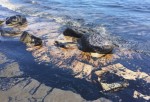
Traveling west along the Gaviota coast on the afternoon of May 19, 2015, Santa Barbara Coastal (SBC) Long Term Ecological Research (LTER) scientists Mark Page and Jenny Dugan and graduate student Nicholas Schooler first noticed a very strong smell of oil starting about a mile east of Refugio State Beach. They decided to park along the highway to take a closer look. They knew what the smell meant; the local news had reported an oil spill from a broken pipeline a few hours earlier. Still, they were not prepared for what they saw: thick black oil washing in and coating the beaches and rocks of the diverse and scenic shorelines all around Refugio State Beach.
Dugan, Page and Schooler are just three of a large group of SBC investigators and students who responded immediately to the Refugio oil spill, pooling their expertise and local knowledge of the SBC LTER area to help with the unfolding spill. Working in collaboration, they are gathering and providing myriad data and observations to state and federal agencies working to clean up and evaluate the damage from the oil spill.
The coast affected by the spill includes a number of SBC long term research sites ranging from kelp forests to sandy beaches. Based at the University of California-Santa Barbara (UCSB), SBC collects a wide variety of data on oceanography, productivity, population biology, and ecology at these and other sites in the Santa Barbara Channel. These extensive SBC time series data will help to evaluate the impacts of the oil spill on coastal ecosystems.
SBC investigators have been leading a diversity of research efforts that employ expertise in oceanography, modeling, remote sensing, microbial ecology, and kelp forest and shoreline ecology to track the Refugio oil spill and evaluate its impacts. Libe Washburn, an SBC investigator and oceanographer and his students are part of a research effort that monitored real-time surface currents and plume trajectory via high-frequency radar. “We have a network of equipment along the coast, and we installed some of our equipment out near Gaviota,” Washburn says. “The new site improved our coverage and our ability to track the oil movement.”
Another pair of scientists, SBC co-Principal Investigator David Siegel, who is a professor of geography and director of UCSB’s Earth Research Institute, and project scientist Leonel Romero, are seeking to shed light on how and where the oil moved. Their ongoing research examines land-ocean interactions in the Santa Barbara Channel to determine how material from coastal streams makes its way into the ocean. “Our focus has been to figure out how coastal streams mix their materials into the ocean,” Siegel said. “We’re taking the same approaches and applying them to a point release of oil just off Refugio Beach.”
Immediately after the spill, SBC researcher Dar Roberts, a geography professor at UCSB, suggested the use of NASA’s Airborne Visible/Infrared Imaging Spectrometer New Generation (AVIRIS-NG) instrument for remote sensing. Two days later, with weather and sea conditions aligned, an AVIRIS-NG team began collecting remotely sensed data along the Refugio coast, from Coal Oil Point to Gaviota. The team also conducted a beach tar accumulation survey about half a mile west of Refugio Beach.
A number of SBC investigators are actively assessing potential impacts of the oil spill on nearshore and coastal ecosystems.
- Craig Carlson, a marine microbial ecologist, and his students are studying the interaction of microbial communities and carbon processing in the oil spill-contaminated waters.
- Uta Passow, a biological oceanographer, and her students have been studying the potential for marine snow formation and sinking of oil from the spill.
- Ecologist Robert Miller and his team were quickly on the scene the first week after the spill to scout the extent of the oil and collect data to investigate the ecological effects of the oil in kelp forests and beneath the ocean.
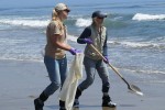
- Ecologist Jenny Dugan and her team collected samples of beach invertebrates before and after the oil washed in on a range of sandy beaches including Refugio, El Capitan, Arroyo Quemado, Coal Oil Point and Gaviota, all of which were potentially affected by the oil spill. They are also investigating the effects of the oil clean up activities on kelp wrack-based beach food webs.
- Carol Blanchette, SBC’s outreach co-director, who leads UCSB’s rocky intertidal ecology program, has been surveying several rocky shoreline sites on Refugio and elsewhere during low tides, documenting species and the extent of the oiling.
The Refugio spill happened more than 40 years after the massive Santa Barbara oil spill of 1969 hit the SBC coastline. The public outcry following that 3 million gallon spill is credited with paving the way for numerous pieces of new environmental legislation and jumpstarting the environmental movement. Although the clean up of the coastline and beaches following the Refugio spill is now winding down, scientific investigation of the environmental impacts of the spill will continue for much longer. SBC’s scientists will play an important role in determining the extent of those impacts and what may be done to restore this once pristine coastline.
 Enlarge this image