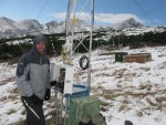
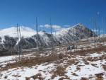
A group of researchers at the Niwot Ridge (NWT) Long Term Ecological Research (LTER) program are using an innovative new research approach to evaluate snowpack conditions across the Rocky Mountain region. Led by Noah Molotch, the group is employing remote-sensing from satellites and automated depth sensors at various elevations on Niwot Ridge to measure the snowpack to augment the existing snow measurement network now used by water managers.
Studies have shown that up to 80 percent of streamflow is derived from snowmelt. As a result, accurate estimates of the snowpack using a measure known as the snow water equivalent (SWE), the amount of water contained in a unit volume of snow, are crucial to water managers to allow informed decisions about water allocation. Current predictions of future water supplies are based on the Snow Telemetry Network (SNOTEL) run by the Natural Resources Conservation Service. Approximately 300 automated stations are located in mid-elevation locations in the Colorado River Basin and measure SWE, snow depth, temperature and precipitation at the point scale. The low density of the SNOTEL network (about one station per 1,000 square kilometers of snow covered land) can be a very poor representation of local snowpack conditions.
The group's research comes to bear in particular with its involvement in the Western Water Assessment, an organization that strives to link research and operations with regards to water supply and demand. A snowmelt perturbation project is currently underway that uses hydroclimatic measurements from NWT to evaluate the effect of landcover change and climate change on streamflow in the Boulder Creek watershed. The project is similarly evaluating other basins in the Colorado Rocky Mountains.
To improve efficiency in water management activities within the agricultural, hydropower, and municipal water demand sectors, Molotch’s group has engaged Denver Water, the Northern Colorado Water Conservation Board, and the National Weather Service’s Colorado Basin River Forecast Center to determine protocols for transitioning the NWT snow research and related data products into operations.
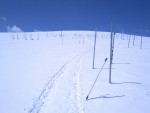
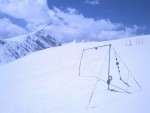
The remotely sensed snowpack conditions provide continuous information over a large area at all elevations, but at 500 meters resolution, while the depth sensors are deployed at three different elevations on Niwot Ridge. NWT hydroclimatic measurements are then used to evaluate remotely sensed and modeled SWE across a gradient that includes forested and alpine terrain. Automated snow depth measurements are made at about 3,022m, 3,300m and 3,528m with a cluster of ultrasonic depth sensors that measure snow depth every hour. The measurements from these sensors combined with detailed snow pit measurements from other groups to provide detailed information that is used as input into physically-based snowpack models.
The only one of its kind in the world, the research by Molotch’s group leverages both remote sensed and on-location snowpack measurements to estimate the snowpack distribution over the larger Upper Colorado River basin. The hydroclimatic measurements from NWT are an important piece of the effort because they provide ground-truth with which to validate the larger regional effort.
 Enlarge this image