A collaboration with the Center for Rapid Environmental Assessment and Terrain Evaluation (CREATE) at the University of New Mexico is providing near real-time satellite data for most LTER sites. The direct readout facilities at CREATE download direct broadcast MODIS data from both the Aqua and Terra satellites.
The significance of the direct broadcast data from CREATE is two-fold:
- The data can become available less than an hour after a satellite overpass
- The data from a single overpass rather than compositted archive data is more timely
The near real-time data provide information immediately following disturbance events such as hurricanes, storms or fires. Test acquisitions for some LTER sites started in July, 2007, with the remaining sites coming on-line by January of 2008. Currently 22 of the 26 sites are within view of the CREATE satellite antennae and efforts are underway to access direct broadcast data from other receiving stations to cover the rest of the LTER Network.
How it works
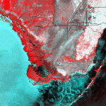
Automated processing extracts MODIS data from the CREATE processing stream for 128 km by 128 km regions encompassing the LTER Network sites. Depending on the MODIS data product, the resolution varies from 250 meters for MODIS bands 1 and 2 and related products such as normalized vegetation indexes (NDVI), 500 meters for MODIS bands 3-7 and related products, and 1000 meters for other MODIS data. Custom data products or different areas can be added based on feedback from LTER site scientists.
The MODIS products produced by CREATE are similar to the standard data products distributed by NASA's distributed active archive centers (DAAC), except that each product is data from a single satellite overpass rather than aggregated data more commonly acquired from the DAAC such as the 16-day Composite NDVI data product. A disadvantage of the single satellite data is that the satellite look angle and the time of day the image is acquired will influence the quality of data, and the user must consider this in the use of the data.
Simple JPEG browse images are produced first in the processing and are meant primarily as a reference to see if the data from a satellite overpass are present and acceptable. The second part of data processing produces standard data products such as NDVI, reflectance, or thermal radiance products. All of these products are translated to standard GEOTiff format for input to standard GIS and image processing software such as ENVI, or Erdas/Imagine.
The data products produced for each of the LTER sites differs for terrestrial and aquatic/coastal sites, with products such as NDVI, fire, and surface temperature produced for terrestrial sites and standard products such as sea surface temperature added to coastal sites. More information and access to the data can be found on the LTER remote sensing/GIS web page at http://www.lternet.edu/technology/ltergis/ or on the CREATE web site at http://create.hpc.unm.edu/create/lter.php
 Enlarge this image