The El Niño-Southern Oscillation (ENSO) phenomenon influences precipitation and climate in many parts of the globe. The extremes in the fluctuation in the ENSO pattern produce major anomalies in atmospheric circulation that extend well into the temperate zones. Wintertime conditions over regions as distant as the United States and New Zealand are affected. One extreme of the ENSO phenomenon, associated with an increase in upper- ocean temperatures in the eastern equatorial Pacific, is called an El Niñoevent. The opposite extreme, linked with colder than normal water in the tropical Pacific, has been called an anti-El Niñoevent or, more recently, referred to as La Niña. Presently, a La Niña event with oceanic conditions stronger than any such event since the 1973-1975 period exists in the tropical Pacific.
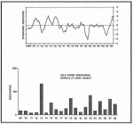
Climatologists and oceanographers maintain a careful watch on the status of the ENSO phenomenon. One valuable index for judging conditions associated with the ENSO phenomenon is the difference in the monthly mean for sea level pressure anomalies at Tahiti and Darwin, Australia (see figure). The monthly atmospheric indices are standardized by the standard deviation of the appropriate long-term monthly mean at each station. The period from August to November of 1988 has had four positive values between 1 and 2. The present index is higher than at any time since 1975 and indicates that a strong La Niña phase is now occurring. The data used in this figure and other climate diagnostic information are available free of charge in the monthly Climate Diagnostic Bulletin which can be obtained through the Climate Analysis Center, W/NMC52, NOAAINWS/NMC, Room 605, World Weather Building, Washington, D.C. 20233. Please specify that you wish to receive the Climate Diagnostic Bulletin.
An example of the relationships between the ENSO phenomenon and winter precipitation patterns in North America can be seen in spring runoff from the Gila River in New Mexico. Spring discharge from the Gila River near Gila, New Mexico, a site approximately 200 km southwest of the Sevilleta LTER and 175 km west of the Jornado LTER, is plotted for 1969-1988. Spring runoff of snowmelt from a mountainous region such as the Gila drainage basin is a good spatial and temporal integrator of regional precipitation from the late fall until early spring. The two highest spring discharges from the Gila occurred in 1973 and 1983 after the strong El Niño events of 1972-73 and 1982-83. Another year with higher than average spring discharge, 1987, followed the moderate El Niño event of 1986-87. La Niña events have generally been associated with reduced spring discharge from the Gila. The extended period of positive anomalies in the Southern Oscillation Index from the middle of 1970 until early 1972 were reflected in very low runoff from the Gila in 1971 and 1972. The two other La Niña events in this period of record, late 1973 to 1974 and mid-1975 to early 1976, also were associated with below normal discharge in 1974 and 1976. No strong La Niña events have occurred since the mid-1970’s until the present conditions which began in the second half of 1988. At the present time, the Southwestern U.S. is experiencing a dry winter.
The ENSO phenomenon has a global impact on climate. ENSO-affected regions are known to typically have greater variability in annual precipitation than regions without direct teleconnection to ENSO. In more northerly altitudes of the U.S., the influence of ENSO phenomena on precipitation may be the opposite of that documented for the Southwest. For example, the Northwest may experience increased winter precipitation during a La Niña phase. It will be of interest to see if, and how, the various LTER sites are affected by this important perturber of global weather during this current La Niña winter.
Additional information may be obtained by contacting one of the authors at the Dept. of Biology, University of New Mexico, Albuquerque, NM 87131.
 Enlarge this image