Hurricane Hugo made a landfall at Sullivan’s Island, South Carolina, at 0001 hours (EDT) on September 22, 1989, two weeks after it had begun as a depression off the coast of West Africa. The storm caused extensive damage to personal property, public facilities, and natural resources, not only in the coastal region but as far as 120 miles inland. Unfortunately, loss of human life did occur; however, the forced evacuation of the barrier islands greatly reduced this toll.
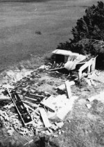
The North Inlet estuary was near the center of Hugo’s fury and the field laboratory complex sustained a frontal attack. The piers, sea water system, and meteorological station were destroyed and parts scattered throughout the marsh and upland forest. The walls of the boathouse were washed away and the roof fell in. Other smaller buildings were also heavily damaged; however, the major damage was to the laboratories.
The sledge-hammer force of the storm surge smashed large holes in the walls facing the marsh. Ocean water gushed through these holes, carrying exterior doors, wood siding, paper, books, furniture, and small equipment to the opposite ends of laboratory buildings. Marsh mud, sand, and Spartina (cordgrass) remnants were found throughout. However, the resident research staff were able to move data records, most of the boats, and the more portable equipment to safety before Hugo struck.
After the storm fallen trees, which had closed the roads and downed utility lines, made it impossible to reach the laboratory complex. On the Winyah Bay side of Hobcaw Barony, the Kimbel Living Center had sustained only minor wind damage. Preliminary damage estimates ranged from $2.5 to $3 million, some covered by insurance.
Fortunately, none of the North Inlet research staff were injured. But the equipment and facilities losses, and the loss of irreplaceable research samples and personal effects, was very demoralizing. However, as scientists we can view Hugo as a special research opportunity. Shortly after the storm, researchers were in the field assessing the environmental well-being of the estuarine-wetlands-upland forest ecosystem. What happened to the detritus, the meiofauna, plankton, and water chemistry is still being assessed, as sampling of these ecosystem components continues.
Many fundamental research questions have been raised which will take considerable time to answer. This event is a fascinating research subject, particularly because no other hurricane has occurred where a comprehensive nine-year database on predisturbance exists.
The information gathered on plant biomass, presence and abundance of species, meteorological factors, soil and water nutrient concentrations, and other features has provided the basis for assessing annual cycles and iluctuations of ecosystem components, as well as investigating how these components interact and function as a whole. This database will provide the frame within which both immediate effects and recovery processes can be evaluated.
Currently, North Inlet researchers are drawing up plans to rebuild and will modernize at the same time. With NSF support, they have begun to look at the effects of the import of saltwater into the forest area. As the ecosystem recovers, researchers must accept the challenge to rebuild and renew efforts to understand the dynamics of the coastal and oceanic zones.
For further information contact John Vernberg Baruch Institute, University of South Carolina, Columbia, SC 29208.
 Enlarge this image