Virginia Coast LTER, the National Park Service, and the University of Virginia exchange high-resolution aerial photography for detailed biological and ground-truth data in a unique collaboration
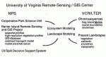
A tentative agreement has been reached with the National Park Service (NPS) to create a Cooperative Park Science Unit which will focus on the barrier islands of the National Seashore at the University of Virginia. The Unit will link remote sensing and geographic information system (GIS) technology with landscape and ecosystem modeling.
The agreement is a culmination of an ongoing relationship of NPS, the Virginia Coast Reserve (VCR) LTER and the University’s Department of Environmental Sciences, which extends back to the early 1970’s when LTER researchers Robert Dolan and Bruce Hayden performed pioneering photogrammetric studies of coastal parks.
Current NPS projects at the University of Virginia complement the remote-sensing activities of VCR in creating GIS data layers for barrier island systems. The NPS Barrier Island Remote Sensing and GIS Project is funded by the Southeast Regional Office of the Park Service. Its objectives are:
- To create winter and summer remotesensing profiles of Atlantic and North Gulf Coast barrier islands
- To develop extremely high resolution (—.2 m) vegetation profiles of barrier islands
- To develop a digitized GIS database consisting of Fish and Wildlife Service ecological inventory maps, Minerals Management Service ecological atlas (this includes socioeconomic areas, soils, hurricane inundation zones, biological resources and oil reserve information), seagrass maps, results of previous vegetation inventories, U.S. Geological Service 1:100,000 digital line graphs (DLGs) of park areas and new 1:24,000 DLG coverages
- To incorporate GIS elements into an inlet sediment transport model for 18 major inlets within Park Service jurisdiction
- To use remote sensing and GIS systems to parametrize spatially explicit ecosystem models and to display model output statistics
To accomplish these goals, an aggressive campaign of aerial image acquisition spanning two coastal LThR sites (VCR and North Inlet) is underway.
Oil Spill Support System
A second NPS-sponsored project, the Oil Spill Decision Support System, involves collaboration between the NPS and the Environmental Sciences and Systems Engineering departments at the University. Students participating in the Capstone program are creating the system which uses GIS elements in support of a decision response system. In addition to GIS-derived data the system incorporates information on historical spills, cleanup techniques, bioremediation techniques, resource availability and socioeconomic impacts. A test is planned near the North Gulf Coast islands in August 1991.
These activities dovetail with the research on transitions and steady-states at the VCR site. Current remote-sensing and GIS projects include the development of long-term chronosequences of shorelines, marsh boundaries and vegetation zones, the characterization of current landscape patterns and the formulation of spatially explicit sediment transport and vegetation models.
The high-resolution aerial photography database provided by NPS has proved extremely useful in establishing up-to- date vegetation maps of the LTER site. Despite the high altitude at which the aircraft flies, photographs clearly show footpaths used by LTER researchers and thus provide an excellent baseline for establishing vegetation cover changes in conjunction with past and future images. LTER modeling activities are facilitated by access to the remotely-sensed data and to the other GIS data layers being compiled by NPS projects.
The NPS projects benefit from the detailed VCR field site biological and ground-truth information, which aids in the development of detailed classification criteria for islands within the National Park system.
RS and GIS Laboratory
Remote-sensing and GIS research activities of the NPS and VCR are conducted in the Remote-Sensing and GIS Laboratory of the Department of Environmental Sciences. The laboratory consists of a network of five Sun workstations and a 386-PC which support a variety of GIS and remote sensing software packages.
Funds to establish the laboratory were provided by the University, the National Park Service and the National Science Foundation.
Contact John Porter or Sam Patterson, Department of Environmental Science, University of Virginia; Clark Hall, Charlottesville, VA 22903, (804) 924- 8999, “jPorter@lternet.washington.edu” (Internet).
 Enlarge this image