As LTER Network scientists focus on broader-scale spatial phenomena, accurate knowledge of their position on the earth’s surface becomes critical. Historically, expansion of the spatial scale of ecological research projects has been hindered by the necessary reliance on expensive and time-consuming traditional surveying techniques. Recently, however, Global Positioning System (GPS) technology has become an integral component of many LTER-related research projects.
Coupled with Geographic Information Systems (GIS), GPS technology can greatly facilitate mapping and research efforts. This technology, developed by the U.S. Department of Defense, utilizes a ground control segment and a constellation of 21 NAVSTAR satellites (plus three spares) orbiting at an altitude of 20,200 km to triangulate positions on earth. Collection of ground truth data in conjunction with GPS data is essential both in poorly mapped regions and where features suitable for ground-based navigation by triangulation are absent. Among other advantages, GPS does not require visibility between sites, fewer personnel are required, and surveys can be performed in inclement weather.
National Science Foundation support has enabled the LTER Network to acquire three Trimble 4000SST GPS receivers (for use where position fixes accurate to a few centimeters or less are required) and 10 Trimble Pathfinder GPS receivers, and to provide a training workshop on collection and processing of both 4000SST and Pathfinder data.
Local arrangements for the workshop, held September 30- October 5 in Boulder, Colorado, were supported by Leanne Lestack (Niwot Ridge). University NAVSTAR Consortium (UNAVCO) personnel, including Randolph Ware (Director), James Stowell and Brennan O’Neill provided training in use of the 4000SST receivers. Barbara Penn (UNAVCO) provided training in processing high-precision GPS data. Chuck Gilbert (Trimble Navigation) and William Michener conducted a short workshop on Pathfinder data collection and processing. Phyllis Adams (Bonanza Creek) and William Jefferson (North Inlet) also provided training in the use of a Geodetic Total Station to obtain elevation and distance measurements.
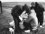
Eighteen LTER scientists participated in the training sessions. Most remained through Saturday for a GPS field campaign conducted at the Central Plains Experimental Range (CPR) LTER site. At six different locations across the site, the field team established concrete benchmarks, obtained precise position fixes for those benchmarks using five 4000SST receivers, and utilized the Pathfinder GPS units to obtain position fixes for fenced exdosures and other CPR field locations. Despite harsh weather conditions on Friday, an excellent database was generated. On Saturday the group returned to UNAVCO where the data were initially processed and Barbara Penn provided additional training.
Participants can now design a field GPS campaign and collect and initially process high- precision GPS data. As the data needs at each site are identified, a schedule for use of the equipment will be developed with UNAVCO. The North Inlet site will serve as the initial point of contact for LTER sites interested in using the 4000SST receivers. Attendees suggested that access to the units would be essential during winter months for temperate forest sites (leaf-off conditions) and during summer months for other sites dependent upon an adequate supply of personnel or restricted by other seasonal weather conditions. Initially, highest priority will necessarily be given to those sites with no nearby horizontal or vertical control points. The North Inlet, North Temperate Lakes and Virginia Coast Reserve sites also presented ideas on how high- precision GPS surveys could eventually become an integral component of ongoing LTER projects.
 Enlarge this image