For the last 10,000 years sea level has been rising and gradually flooding the Atlantic Coastal Plain of North America. As the river valleys of the Susquehanna, Potomac, James, and a series of smaller rivers were flooded, a very large coastal plain estuary was formed: Chesapeake Bay.
The watersheds of the smaller tributaries to this estuarine system, including the Rhode River estuary, lie completely within the coastal plain geological province. Rhode River watershed soils consist of about a thousand meters of sedimentary layers laid down over the eastern portion of the Piedmont geological province at times of high sea levels.
On the Rhode River watershed, however, an impervious layer, the Marlboro Clay, occurs near current sea level, isolating shallow, perched aquifers from the deeper layers. Thus, both the surface and groundwater draining each subwatershed of the Rhode River can be readily sampled, measured, and related back to source areas. In 1965 the Smithsonian Institution made the decision to begin a long-term study of this Rhode River watershed/estuary environmental system.
Site Characteristics
The Rhode River watershed is comprised of 3,300 ha of uplands on the western shore of Chesapeake Bay on the inner coastal plain. It was the home of Piscataway Indians for several thousand years prior to European settlement about 1650. The colonists quickly cleared most of the existing hardwood deciduous forest and established tobacco plantations. The soils are fine, sandy barns and are easily erodible. Mean watershed slopes are about 5 percent. Thus, erosion rates have been very high for over three centuries. Several cycles of forest clearing for agriculture, followed by abandonment to secondary succession are characteristic of the region. A few small relicts of undisturbed forest remain, including a 6-ha subwatershed, but most of the mature forest dates to agricultural lands abandoned in the early 1800s. The soils are very rich in both phosphorus and nitrogen and secondary forest succession is usually very rapid. The watershed is within the tulip poplar association of the eastern deciduous forest biome. Currently, about 35 percent of the watershed is agricultural, mostly in corn production.
The Rhode River estuary joins Chesapeake Bay in its mesohaline reach and, typical of the Bay, is a low-energy, soft- bottom system. It has a surface area of about 550 ha of open water and a mean depth of 2 meters. About 25 ha of tidal marshes occur near the tidal headwaters. Mean tidal amplitude is about 30 cm but extreme tides due to winds and pressure differentials between the Bay and the continental shelf range up to 3 meters. A combination of sea-level rise and regional subsidence results in an increase in mean tidal elevations of about 4 mm per year. Due to seasonal variations in freshwater discharges from the land the salinity at the head of the Rhode River varies from 0 ppt in the spring to about 10 ppt in a normal fall. At the juncture of the Rhode River and Chesapeake Bay this corresponds to about 5 ppt to l5 to 20 ppt.
The Research Program
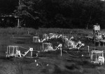
The research program for 20 years has had the goal of understanding how human use of the air, land, and water effects the ecology of the region. Long-term studies of populations, communities, ecosystems, and the overall landscape attempt to establish a better grasp of cause and effect. The research involves both descriptive observations and manipulative experiments. For example, the chambers in the illustrations are used to maintain a continuous elevated carbon dioxide concentration in tidal marsh communities over a period of years. This simulation of carbon dioxide concentrations anticipated in the next century allows measurements of physiological and ecological effects at the community level with only minimal experimental artifacts. The plant communities quickly and dramatically increased their photosynthesis and water-use efficiency and decreased their respiration rates. After four years the plants have not begun to acclimate to this increase in carbon dioxide concentration. Larger chambers are now in use in forest floor communities to examine effects of elevated carbon dioxide on woody species such as Lindera benzoin.
Regional studies use the Rhode River system as a basis for comparisons. For example, a study of the overall Chesapeake Bay watershed seeks to understand the relative importance of geology, land-use patterns, and variations in weather on discharges of nutrients and suspended sediments. Ten coastal plain subwatersheds on the inner, mid-, and outer coastal plain of Delaware and Maryland and 10 sub- watersheds on the inner and outer piedmont of Maryland and Pennsylvania are being compared with nine long-term Rhode River study subwatersheds. Future work will include subwatersheds in the great valley, ridge and valley, and appalachian plateau geological formations of Pennsylvania and New York. Topographic and land-use data for these subwatersheds are entered into ARC/INFO as a data base for landscape-level simulation models of nutrient dynamics. Another regional/continental scale long-term comparative study concerns woodland neotropical migratory bird populations. It focuses on the effects on these species of forest habitat fragmentation in both their mid-Atlantic breeding grounds and their wintering grounds.
The Center has either purchased or helped protect from development about 2,000 ha of the Rhode River watershed and is attempting to protect another 1,000 ha. Facilities at the Center include about 20,000 square feet of office and laboratory space, a Smithsonian branch library, a computer center and local-area computer network, a fleet of vehicles and small boats, a student dormitory, and limited housing for visiting scientists. We have a competitive internship program for undergraduates and a fellowship program for graduate students and postdoctoral fellows.
For further information: David L. Carrell, Smithsonian Environmental Research Center, P.O. Box 28, Edgewater, Maryland 21037-0028.
 Enlarge this image