Succession, disturbance and system state-change
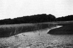
Fourteen barrier islands form the seaward margin of the Virginia Coast Reserve (VCR). Landward there are shallow bays, deep channels, mudflats, salt marshes and a contiguous upland ecosystem on the edge mainland. VCR LTER research at the Reserve focuses on succession, disturbance and system state-change. It is a good place for such research. A wide range of marine and terrestrial successional sequences are evident, both in the patterns of the current landscape and in historical records such as aerial photographs (1949-1990) and land surveys (1852-1949). It is not clear that terminal seral stages are ever reached, because the frequency of disturbance is high.
In addition to succession and disturbance, fundamental transitions of system states have occurred. In the 20th century alone, terrestrial forests and farmland have changed to salt marsh; maritime forests to grasslands; and clear-water lagoons with seagrass meadows to mud-bottomed, turbid water lagoons.
Contemporary rates of landscape change are very rapid. Erosion of the shoreline along the VCR barrier islands averages 5 meters per year and locations with rates two to three times higher are common. The rapid changes (in both ecological and human terms) make the site ideal for the study of long-term ecosystem dynamics.
In our research we have identified four processes (disturbance, groundwater availability, sea-level changes and succession) which dominate the VCR landscape. We are currently working on five major experiments (three of them manipulative to test and expand our understanding of pattern and process in a barrier island system.
Parramore Pimples Experiment
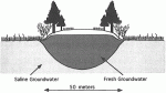
The Virginia Coast Reserve is in the process of installing its Parramore Pimples Draw Down Experiment. The pimples of Parramore Island (which owe their name to their appearance on aerial photographs) are small, nearly circular mesas of sand, which are 30 to 50 meters in diameter and perched on a saline to brackish marsh surface. Elevations vary from a high of 2 meters to a low of several centimeters. The pimples rest on a substrate that has saline porewater, but the pimples themselves have a lens of fresh water. The fresh-water lens is replenished by rainwater and drawn down by evapotranspiration. There is no stream flow, and mixing with adjacent saline groundwater is minimal.
Vegetation cover varies with pimple size and elevation. The smallest pimples are covered by a Spartina patens grassland. Larger pimples have a series of concentric zones. An arid “desert” in the center is surrounded by a sparse grassland, an eastern red cedar (Juniperus virginiana) forest ring, followed by an Iva sp. shrub zone, then a Spartina patens grassland ring around the pimple and. finally, a Distichlis spicata and Spartina alterniflora marsh. The largest of the pimples are forested with a central parkland.
Lack of horizontal groundwater mixing makes the Parramore Pimples act as natural lysimeters, making them an ideal place for studying the relationships between soil water and vegetation. We will install solar-powered water pumps to draw down the groundwater; for a 50meter diameter pimple, for example, the water table will be drawn down by up to 3 mm per day on the sunniest days, a rate comparable to a thick stand of shrubs. We will control the rate of draw down and remove water from one pimple, pumping it onto an adjacent pimple of similar structure, thereby augmenting natural rainfall. A third pimple will be designated as a control and all three will be monitored. The experiment will allow us to test our understanding of hydrologic and vegetation processes, as well as determine system responses to changes in climatic rainfall regimes.
Disturbance Experiments
At the VCR, nature provides ample opportunities to follow the consequences of disturbance. Waves and surges from coastal storms move large volumes of sand across the barrier islands, creating overwash fans. Some of these fans cross the island and form platforms in the lagoons on which new marshes develop. We monitor the vegetation recovery from these disturbances, record the changes in extent of the various land-cover types of the islands, and follow the evolution of new landscapes. The data from these programs are used to parameterize models of landscape and ecosystem dynamics. Sand deposition on the islands also results in greater volumetric catchments for rainwater and larger freshwater reserves which is used by vegetation and lost as evapotranspiration. Sand deposition, integrated over time, gives rise to the freshwater resources needed to support high leaf area index vegetation, such as forests.
Sea Level and Marsh Lowering Experiment
Relative sea levels along the mid-Atlantic coast have been rising about 25 cm per century for the last 500 years. During 1992, we began a series of marsh surface lowerings as proxy studies for marsh changes in response to accelerated sea-level rise. In these experiments, sediments below the rooting zone are excavated at low tide and the marsh surface is permitted to sink lower in the water column. We hypothesize that Spartina alterniflora will change from the short form to the intermediate form in response to accelerated sea-level rise. These mechanical alterations of the marshes will be replicated during the 1993 field season and Spartina alterniflora productivity in the lowered and control areas will be determined.
Marsh Flume Experiment
Sea-level rise in marsh environments is often manifested as greater frequency of tidal submergence. For a given marsh, the frequency of tidal submergence is changed as sea level rises. We are installing a series of small flumes and control plots to test the hypothesis that the frequency of submergence regulates marsh community structure in the high marsh. Flooding frequency will be increased using small pumps to move water from tidal creeks to marsh surfaces within the flume. The semi-porous side-walls of the flumes will retard the rate of water flow on the ebb tide increasing flooding duration. Changes in sediment pore water chemistry and shifts in plant community composition and productivity will be measured. These flumes will be installed during 1993 as a prototype for a more extensive and replicated series of experiments in subsequent years.
North Hog Chronosequence
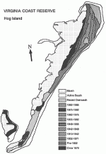
The ages of landscape elements on Hog Island have been determined from aerial photographs (1949-1990) and field surveys (1852-1949) using geomorphological techniques (Figure 2).
From this data set the successional chronosequence for the Hog Island Transect No. 1 has been established.
Surveys of soil nutrients along the 120-year chronosequence were reported on at our annual LTER project symposium in January11-12, 1993. Landscape age within the chronosequence is being correlated with primary production, soil organic matter and water table elevations. These studies will form the benchmark for succession studies on new landscapes created by coastal storms.
Information on recent VCR research has been compiled in a 1993 symposium volume available from: Bruce P. Hayden, Environmental Sciences, University of Virginia, - Clark Hall, Charlottesville, VA 22903, 804-924-7761, BHayden@LTERnet.edu.
 Enlarge this image