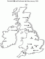
The U. K. Environmental Change Network (ECN) moves into the implementation phase during 1993, with nine terrestrial sites scattered across England, Scotland and Northern Ireland. The entry into the Network of seven English and Welsh river sites heralds the development of an analogous series of freshwater sites in ECN terrestrial sites scattered across England, Scotland and Northern Ireland. The entry into the Network of seven English and Welsh river sites heralds the development of an analogous series of freshwater sites in ECN.
In 1989 a Working Party on Long-Term Reference Sites, chaired by Dr. Bill Heal of the Natural Environment Research Council (NERC), recommended the establishment of a network of sites across the United Kingdom for environmental monitoring. ECN, officially launched in 1992, is supported financially by a consortium of nine major U. K. organizations, each of which has a strong commitment to environmental research and management. The Network is a community response to the need for long-term data on the environment. ECN has been designed as an integrated monitoring network; although closely related to research projects at several of the sites, it is not explicitly process-oriented.
The ECN’s primary purpose is to identify and quantify environmental changes associated with human activities, distinguishing man-made change from natural variations and trends and giving early warning of undesirable effects. The operation of the Network depends on the voluntary collaboration of the sponsoring agencies in providing sites and the necessary funding for staff to carry out the monitoring program. Scientists from a number of research institutes and the universities have collaborated in devising protocols intended to ensure that measurements are standardized at all the sites and that there are appropriate quality assurance procedures. Managers at each site are responsible for ensuring that the protocols are followed and that the data are sent in standard format to a central data facility.
The Sites
In selecting sites we have attempted to capitalise on established sites with known management history and to take advantage of existing data and understanding. A list of 24 such terrestrial sites was drawn up which represented the broad range of climate, soil, habitat and land management in the United Kingdom. It has been possible to recruit nine terrestrial sites into the network so far; it is expected that two others will be committed this year and that others will join later. The sites range from intensively-managed lowland agricultural establishments to semi-natural upland areas, the largest being about 80 km2.
The Measurements
Standardized recording of an agreed suite of selected environmental attributes and variables has started in 1993 with the aim of continued long-term integrated monitoring. The nature of the measurements demands that some are concentrated on a small area of I ha, while others are more extensive and cover the whole site. A number of physical and chemical features of the environment are being recorded. Meteorological recording uses both Q. automatic and manual systems; regular samples of rainwater are collected for chemical analysis, and diffusion tubes collect some pollutants such as NO2 sites with perennial streams will record discharge and water quality. Soils are being sampled on a five-year cycle for a number of chemical and physical determinants and soil water is being extracted by suction lysimeters from two soil horizons for analysis at fortnightly intervals.
The biological part of the program relies on traditional methods of data collection. Vegetation at the sites will be surveyed and characterized by using an existing national classification. Permanent quadrats will then be located to cover the range of variation and will be recorded at intervals of three years to examine any shifts in species composition and frequency. Linear features such as hedgerows and vegetation boundaries are of particular interest. At agricultural sites additional measurements will be made of grass and cereal production.
Recording of animals has been directed towards groups thought to be good indicators of environmental change. Animal groups with wide distributions can be used for intersite comparisons of possible changes with time; those for which there are already national monitoring schemes, and into which results from ECN sites can feed, such as common birds, have particular attraction. Bat surveys will use existing, well-tried techniques to assess year-to-year changes in populations of this climate-sensitive mammal, which can be monitored using ultrasonic detectors. Frogs are known to be sensitive to some pollutants and there is a marked geographical trend in their spawning dates whose pattern may be affected by climatic changes; spawning dates and breeding success will be monitored. Surveys of changes in rabbit populations should provide information on how changes in weather, disease and land-use affect their numbers
A number of invertebrate groups have also been included in the program. Moths and butterflies are already monitored nationally and it is planned that ECN sites will link with these existing programs. as well as other groups monitoring spittle bugs, crane- flies and ground beetles, which have no existing national networks, but are also included as indicators of environmental change.
The ECN program is managed by a central coordination unit based at the Institute of Terrestrial Ecology’s Merlewood Research Station in Cumbria. In addition to the ECN Coordinator the team consists of a data manager. a statistician and the managers of the two NERC-sponsored sites. An ECN database is being developed at Merlewood to handle and make accessible the large quantities of data which the program will produce. A meta-information system will contain vital information describing the origin of the data, and their spatial and temporal characteristics, as well as their quality. Digital map information describing the spatial variability of measurements within and between ECN sites is being established in a geographical information system: this is integrated with the database and with the meta-information, for spatial analysis and modeling. The database will be accessible to registered users over the JANET network.
The Next Phase
ECN recording has begun in earnest in 1993, a trial year during which the measurement protocols will be tested and after which some modifications may be necessary. The next phase is the expansion of the Network into the aquatic environment— beginning with the selection of seven river sites across England and Wales at which a wide range of measurements were started in April 1992. Possible sites, measurements and funding mechanisms for other rivers and lakes in the United Kingdom are under consideration. At a later stage it is envisaged that the scope of the program might be extended by including estuarine and marine sites in ECN.
J. Michael Sykes is Coordinator of the U. K. Environmental Change Network at the Natural Environment Research Council’s Institute of Terrestrial Ecology, Merlewood Research Station, Grange-over-Sands, Cumbria L411 6JU, 05395-32264 (phone), ME_ML@UK.AC.NMW.VA (e-mail).
 Enlarge this image