With an objective of developing regional ecosystem analysis capabilities, scientists from LTER and NASA have been planning a coordinated network for regional measurement of terrestrial vegetation attributes in conjunction with the EQS/MO DIS Land Remote Sensing Team. Specifically proposed in a workshop at the 1993 LTER All Scientists Meeting are the production of spatial datasets of three fundamental ecosystem variables: land cover, leaf area index (LAI), and aboveground net primary production (ANPP) for regional-scale landscapes representative of each participating LTER site. The effort expects to define science objectives in two areas:
- What methodology and sampling logic is optimum for sampling these ecosystem attributes over large scales
- What remote sensing/modeling procedures best discriminate the observed regional array of these ecosystem variables
Each interested LTER site has been asked to describe an accurately georeferenced 10 x 10 km2 area representative of its regional landscape. A nominal cell resolution of 30m (TM pixel) with 1-km pixel aggregates will be used as a basic test. Sites were also asked to specify a plan for producing the three data layers, including a schedule, personnel requirements, and a three-year project budget. A joint proposal to NASA and NSF has been submitted and the primary field season is planned for summer 1995.
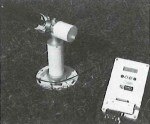
SUN Photometer
Initial LTER-NASA workshops identified Sun photometers as essential for atmospheric correction of satellite data. An LTER supplemental proposal funded in part by NASA will implement an initial network of automated photometers which relay data in real time to Goddard Space Flight Center for processing, distribution to LTER sites, and archiving.
A November 1992 training workshop to initiate collaboration also provided an opportunity to design links between Goddard and LTER computer systems, and develop a joint proposal for full development of the atmospheric correction activity. Photometer and GOES satellite links orders were placed in November 1993, and a training session for LTER site representatives was held at the Sevilleta site March 18-20, 1994.
In Year I, installation is planned for the Sevilleta, North Temperate Lakes, McMurdo and Palmer stations, H.J. Andrews, and Bonanza Creek sites. A NASA instrument may also be available for individual campaigns.
Communications
At the All Scientists Meeting workshop, one group focused its discussion on capabilities and limitations of current satellite and airborne sensors, and identifying appropriate ecological investigations. One central issue emerged:
information about remote sensing capabilities and limitations, available instruments and darasets, and near-future opportunities is not accessible to ecologists. To improve accessibility, the group proposed to:
- Establish programs to facilitate working visits of LTER scientists to NASA Centers and of NASA scientists to LTER sites
- Undertake special efforts to add LTER scientists to relevant NASA mailing lists
- Develop materials to inform scientists about remote sensing and the capabilities of existing sensors, as well as near-term future opportunities
- Develop a series of workshops or trainings for NASA and LTER remote sensing specialists.
Collaboration Status
- John Vande Castle (Network Office) is coordinating access to 1992 and 1993 Landsat Thematic MapperTM data acquired by NASA for global change research. Satellite and GIS data previously acquired and processed are archived on-line for LTER researchers on the LTER server, LTERnetedu. A metadata description will be developed and linked to the Mosaic/gopher/WIS software access.
For more information: John Vande Castle, 206-543-6249, jvc@LTERnet.edu
 Enlarge this image