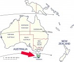
After a long gestation period, the Warra LTER site is now fully operational in Tasmania. The site is 15900 ha and predominantly temperate Eucalyptus forest and rainforest.
We have been greatly assisted in the establishment of our site by the on-ground visits of Fred Swanson and David Post from the HJ Andrews LTER Site. Fred also was key-note speaker at a seminar in Hobart and was an excellent catalyst to enthuse the local scientific community about the benefits of LTER.
Since the early 1990s there have been a number of stop-start attempts to get the LTER concept established in Australia. There are several places around Australia that have the attributes of LTER sites in various biomes (e.g. temperate and tropical broadleaf forests, the Great Barrier Reef, arid and semi arid lands and at least one urban ecology site) but until now none has been so designated. We hope that the Warra site will be a precursor to a truly national system and will link to the ILTER. Negotiations are currently taking place to establish a formal national system through the National Forest Inventory and thence to establish formal links with ILTER.
The Warra Long Term Ecological Research Site, Tasmania, Australia is a temperate broad leaf forest (mainly Eucalyptus obliqua wet forest) with some areas of moorland, alpine, temperate rainforest, riparian forests, conifer forest and scrubs.
The Warra LTER site has been established to facilitate the understanding of ecological processes of Tasmania’s wet (Eucalyptus obliqua) forests. These forests are part of the southern cool temperate wet forest biome. The programs foster multi-disciplinary research within a long-term framework. The site contains both working forests and conservation reserves. Appropriate management prescriptions and practices prevail in different parts of the site.
The main goals include:
- Understanding fundamental ecological processes in E. obliqua wet forests; assessing and monitoring biodiversity and geodiversity
- Determining the long-term effects of different forest management regimes on natural diversity and ecological processes and thus assess their sustainability; developing alternative management regimes (where necessary)
- Providing an integrated multi-disciplinary focus which complements research programs elsewhere in Tasmania, and; linking Tasmanian forest research with national and international programs having a long term ecological focus
The site is partly within the Tasmanian Wilderness World Heritage Area, which is managed for conservation, and partly within State forest, which is managed for multiple purposes including wood production. There has been a history of data collection for forestry purposes since the late 1960s. Parts of the area were first harvested in the early 1970s. The complete logging history, recent fire histories and vegetation survey data are available.
Data sets include:
- GIS layers have been collected at 1:25000 scale and include:Forest type maps (vegetation structure) derived from aerial photography; geology, vegetation, fire history, modelled climate surfaces (ESOCLIM), satellite images, aerial videography, environmental stratifications.
- Hydrology and climate. There are weirs constructed (or modified) and instrumented on Warra Creek, Swanson Creek and King Creek. Sampling commenced in 1998. There is an operational weather station on Manuka road and 17 fortnightly river sampling sites on Manuka, Warra and South Weld roads. A second weather station is to be established at the top of the catchment. 3. Forest productivity. Continuous forest inventory plots (CFI) have been established in the area since the late 1960s - early 1970s. These are measured at establishment, at 5 years, 10 years and then 10 yearly. 4. Biodiversity. Species lists (and locations) are available for vascular plants, vertebrate fauna and some non-vascular plants and invertebrate groups.
A stratified system of baseline long term vegetation monitoring plots is being established at Warra, to complement the CFI plots.
Some current research projects include:
- Aquatic–1.1 Hydrology: Water quality and flow through the three weirs pre- and post-harvesting of the King Creek catchment. Aquatic invertebrate indicators of river health.
- Biodiversity–2.1 Baseline biodiversity monitoring plots 2.2 Effects of alternative silvicultural systems on biodiversity. Compares the relative impacts on biodiversity of partial logging with low intensity burning and clearfelling with high intensity burning with and without the retention of understorey islands. Studies include mammals, birds, selected invertebrate groups, vascular plants and selected non-vascular plants. Effects of newly created edges on microclimates and epiphytes.
- Silviculture–3.1 Native forest silvicultural systems-wet eucalypts: a replicated trial comparing clearfell, burn and sow treatment with a limited set of feasible alternatives. Aspects of the study include quality and quantity of eucalypt and special timbers regeneration, productivity, cost, worker safety, biodiversity retention and soil sustainability. Long term response to thinning in E. obliqua forest.
- Soils–4. 1. Procedures for the measurement of changes in soil physical properties and soil organic matter following logging of wet E.obliqua forest, and the subsequent effect on site productivity.
Modelling and remote sensing:Landscape dynamic modelling of the ecology/stand dynamics/fire history of E. obliqua forests. Aerial videography. Use of satellite imagery for productivity estimation.
Facilities: The Warra LTER Site is 1 1/2 hours drive from Hobart, and has several major roads within its boundaries which provide access to the eastern half. The western half of the area is effectively wilderness with access only by foot, or by river. Several permanent tracks have been established for long term monitoring within the area, both within the working forest and in the wilderness forest areas. Accessible control areas occur in the vicinity.
Currently there are no on-site accommodations or laboratory facilities or field stations in the area but there is shelter, toilet and barbecue facilities located on the Huon River at the entry to Warra. The Huon District Forestry Office is in Geeveston, 40 minutes from the site.Laboratory space at Hobart may be available through negotiation with the Tasmanian land management and research agencies represented on the Policy Committee.
Research and Data management: The site is managed by a cooperative which includes Forestry Tasmania, Parks and Wildlife Service, Forests and Forest Industry Council, Bureau of Resource Sciences, University of Tasmania, the CSIRO and the Cooperative Research Centre for Sustainable Forest Management. Data are managed and curated by the individual research agencies, with common data sets on vegetation and biodiversity, climate, soil, water and geology, being held by FT and PWS. Data will eventually be available via the web site.
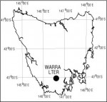
Location: 146’ 40" East, 43’ 04" South Near the junction of the Huon and Weld Rivers in southern Tasmania, Australia. Elevation: 37–1 260 m. Area: 15 900 ha.
Contact: Coordinator: Dr. Mick Brown, Assistant Chief, Division of Forest Research and Development, Forestry Tasmania, 79 Melville St Hobart Tasmania 7000.
ph +61-(0)3 6233 8202
fax +61 (0)3 6233 8292
e-mail:mick.b@forestry.tas.gov.au
www.warra.com
 Enlarge this image