The Virginia Coast Reserve (VCR) is one of only two coastal estuarine LTER sites (the other is the new Plum Island (PIE), Massachusetts site, a former LMER site) and, as such, faces some long-term threats unique to these sites – namely, sea level rise.
Although the magnitude of the sea level rise problem remains a subject of some controversy, it is clear that in many areas, most notably along the Gulf Coast, that marshes are both eroding and subsiding, resulting in long-term losses of deltaic marshes. Such a pattern has also been found in the Chesapeake Bay area as well where the deep peat-based marshes of the middle Eastern Shore have long been shown to be reverting to open water.
Across the peninsula, the islands and marshes of the Virginia coast experience an extremely high rate of local change (ca. 3 mm/year). Some evidence also suggests that lagoonal marshes are either fragmenting or high marshes are reverting to low marshes, i.e. sea level rise may exceed marsh accretion rates.
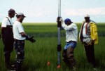
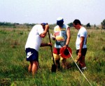
Several investigators of the VCR LTER (Mark Brinson, Linda Blum, Bob Christian, and Pat Wiberg) have been studying the marshes at Phillips Creek, an oceanside mainland marsh, since 1986. In 1997, with the cooperation of Don Cahoon (National Biological Service), a series of sedimentation erosion tables (SETs) were installed to accurately measure (+/- 2 mm) and segregate the changes in marsh surface due to accretional processes from those associated with shallow subsidence.
The SET consists of a geologically stable platform that includes a stainless steel pivoting arm with nine vertical pins to measure distances to marsh surface. Measurements will be made at least semi-annually at each monitoring station to reflect mineral deposition and organic matter accumulation rates to reveal mechanisms contributing to changes in marsh surface elevations. This information, combined with tide gauge data, will reveal whether these marshes are able to keep pace with sea level rise, or whether they are "losing ground." In the near future, more SETs are planned for several lagoonal marsh islands in coastal Virginia and elsewhere along the Atlantic coast to expand the network of marsh monitoring.
On a larger scale, the VCR and PIE LTERs have been using kinematic Global Positioning System (GPS) technology to construct topographic data layers of marsh surfaces. VCR Site Manager Randy Carlson spent a week at PIE developing a set of high-quality topographic and geographic benchmarks. These were then used to anchor kinematic GPS surveys of the marsh surface. This matches similar efforts on Phillips Creek and Hog Island marshes at the VCR. Coupled with the SET measurements, the GPS-generated topographic surfaces provide a way to estimate the spatial extent of expected areal change due to sea level rise, as well as providing a comparative basis for future studies of VCR and PIE marshes.
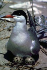
Another effort that will allow intersite comparisons is the experiment involving SETs inside impoundments at the Indian River Lagoon (IRL) where the Merritt Island National Wildlife Refuge managers control hydroperiods. Comparisons between IRL and VCR will allow researchers to determine how elevations in marshes respond to changes in the relationship among the three free surfaces of land, and fresh- and salt water. As part of a study begun in summer 1998, led by VCR LTER PI Michael Erwin with cooperators including Cahoon and Charles Roman, several lagoonal marsh islands in the VCR LTER site, Maryland, southern New Jersey, and Cape Cod, Massachusetts, will be selected for intense studies of sea level rise, marsh dynamics, and migratory waterbird use.
The central hypothesis being tested is that marsh islands are not able to maintain position with respect to sea level rise, that they will undergo greater fragmentation and loss, and that many waterbird species, especially marsh-nesting species, will be adversely affected, while some guilds such as migrant shorebirds may benefit to varying degrees.
Sites will be selected that are important migratory bird use areas such as national seashores and national wildlife refuges, where historical information is available, and where marshes may be at some risk. Information will be collected on marsh changes based on historic charts and photographs to compare with recent satellite imagery and aerial photography to help in the selection process. By collecting data on habitat use throughout the year for more than 75 species of waterfowl, shorebirds, and colonial waterbirds (wading birds, gulls, terns), critical habitats for nesting, feeding, and roosting will be assembled. These data, combined with historic documentation of bird survey data, will reveal both trends in species numbers and will indicate the degree of plasticity of species. This, in turn, will allow researchers to rank the relative vulnerability of species to changes in marshes. Researchers will also be able to indicate which suite of species is likely to benefit if marshes revert to intertidal flats and open water. For species that breed in marshes, landscape analyses will be used to determine how local marsh changes may affect the viability of the regional population (i.e., the metapopulation).
In another effort, begun years earlier, Erwin and colleagues from partner organizations, the USGS, The Nature Conservancy, the College of William and Mary, and the Virginia Game and Inland Fisheries Department, have been collecting data since the mid 1970s on breeding populations and colony site use by more than 25 species of waterbirds along the Virginia barrier islands. The data have been entered into a GIS and will be analyzed to determine the degree to which physical attributes at the local and regional scales influence colony site dynamics by each species or group.
Combining the information from these efforts should enable biologists to determine the spatial and temporal risks of marsh loss, the number of waterbird species that benefit or are adversely affected by potential marsh changes, and with spatial modeling, should allow predictions to be made of how dynamic habitat changes will influence not only population trends by species, but also how colony nesting site and feeding distributions will change with incremental changes in relative sea level. Model results can then be tested in a number of other estuaries along the Atlantic and Gulf coasts to see how generalizable the pattern appears to be.
Rising Seas and Changing Marshes: Predicting Effects on Waterbirds
By:
John Porter (VCR) By:
Michael Erwin (VCR)  Enlarge this image