CAP LTER Research
Preliminary Results from the 200-Point Survey
by Dr. Diane Hope, CAP LTER Field Director
In spring 2000 CAP LTER researchers undertook a major field survey as part of the project's core monitoring efforts. The survey's goal was to measure key ecological characteristics of the study area, provide a baseline for future monitoring, and give an overview of features such as plant diversity, soil chemistry, etc., which can only be gained through field investigations. The entire study area (some 6,400 km2) was covered with a 5 x 5-km grid. In the developed urban areas, one such point was located in every grid cell, while in undeveloped land, one random point was chosen in every third grid. This method resulted in 206 sample sites, of which we surveyed 204 between February and May 2000.
Field measurements were done in 30 x 30-m survey plots and included identifying all native and exotic plant species to genus; mapping the area of surface cover types; collecting samples of soils, insects, microbes and pollen; and taking cardinal-direction photos from the center of each plot. Since this survey, bird abundance and diversity, along with human activity, has been monitored at 40 of the 204 sites, 4 times a year.
The field data has been entered into the CAP LTER database and is now available to researchers. All major plot features (surface cover types, built structures, individual trees and shrubs), along with locations of soil, prokaryote, and pollen samples within the plot are fully geo- referenced. Lab analysis of pollen and litter bags for decomposition are complete, while soil chemistry (pH and major nutrients) and textural analyses will be completed shortly.
The dataset is intended to provide a comprehensive picture of select ecological characteristics of the Phoenix metro area and surrounding agricultural and desert lands, at one point in time. However, the sites will be resurveyed every 5 years to monitor how these variables change over time and with continued development. Another use of the data is to compare features such as plant diversity and soil nutrient status in the city and the outlying desert. Preliminary analyses by Steve Carroll show that total plant diversity becomes greater as the elevation of the site increases, and soil nitrate-N content decreases from south to north.
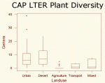
Human geographic and socioeconomic variables are also important factors in explaining spatial patterns in plant diversity and soil-nutrient status. In general, plant diversity was similar between desert and urban sites, although the total number of plant genera was higher for urban versus desert sites, similar to findings in European cities, which have higher plant diversities than their surrounding country sides. Even more interestingly, human geographic and socioeconomic variables are also important factors in explaining spatial patterns in plant diversity and soil-nutrient status. Both median family income and human population density are both positively correlated with plant diversity. In other words, wealthier neighborhoods and those with more residents tend to have a greater number of plant types.
Meanwhile soil nitrate-N content was related to the type of land use. Plots dominated by transportation use, in urban and fringe areas on average have the highest N contents, while desert sites have the lowest. Soil nitrate-N content was also related to human population density (soil nitrogen contents were higher in plots located in more populous neighborhoods) and proportion of impervious surface cover (the more concrete and asphalt at the survey site, the lower the soil N content). These preliminary findings are the subject of ongoing studies by CAP LTER researchers.
 Enlarge this image