For over seven years the Santa Barbara Coastal (SBC) Long Term Ecological Research (LTER) Program has been using satellite imagery to track changes in giant kelp canopy cover and biomass at the SBC site (Network News Fall 2007, Vol. 20 No. 2). This satellite imagery has enabled SBC scientists to scale up field measurements and examine regional dynamics of giant kelp forests. Data from this project has been used to examine the drivers of seasonal, annual, and decadal fluctuations in kelp abundance and productivity, characterize the population dynamics of kelp forest ecosystems, and explore the role of disturbance in structuring kelp forest food webs.
However, processing and analyzing this satellite imagery is incredibly time and work intensive. As a result, these remote assessments of giant kelp so far have only been performed on southern/central California and Baja California, Mexico. Now a team SBC scientists led by Kyle Cavanaugh from the University of California-Los Angeles and Jarrett Byrnes from University of Massachusetts, Boston are turning to citizen scientists to help map changes in giant kelp abundance on global scales. The scientists have teamed with Zooniverse, an organization that creates citizen science websites, to launch Floating Forests, a web-based project to map the world’s giant kelp forests.
This project is using a time series of Landsat satellite imagery to examine changes in giant kelp forests over the past 32 years (from 1982 to the present). The researchers are using data from Landsat 4 (1982-1993), 5 (1984-2011), 7 (1999-present), and 8 (2012-present). This series of satellites provides about 1-2 images per month from 1982 to the present for most parts of the world, allowing researchers to examine giant kelp canopy dynamics on seasonal, annual, and decadal time scales.
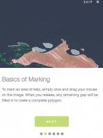
Before the images are given to users they undergo a preprocessing and subsetting procedure. Each Landsat image represents about 200 km x 200 km, and it is very difficult to see the kelp canopy at that scale. In addition, the majority of each image consists of land or open ocean, areas where kelp is not found. So the raw image is broken into smaller 10 km x 10 km image segments and then the non-coastal image segments are discarded. Figure 1 gives an example of a typical image segment that a user might see it.
Giant kelp canopy is easy to detect on these images because the canopy has much higher near-infrared reflectance than water. The images provided to users are known as false-color images. In these images near-infrared reflectance is displayed in green, giving the canopy a green tint (giant kelp canopy typically appears reddish-brown to the naked eye) and making it easy to distinguish. Users then simply outline the canopy with their mouse, as in Figure 1.
A key feature of Zooniverse’s approach to citizen science is that each image segment is classified multiple times by different users. Although individual users will make errors, scientists can calculate reliable estimates of the mean and uncertainty from the repeated classifications. Additionally, the first phase of the project includes images which have already been classified by experts at SBC and cross checked against field data. Comparing the citizen science data to these existing estimates of kelp cover will provide a further check on the biases and uncertainties in the Floating Forests approach.
During the first month of the project, more than 2,000 unique users classified over 700,000 image segments. The first phase of the project has focused on California and Tasmania, but soon the project will be expanded to other regions that contain giant kelp, such as Baja California, Chile, Peru, the Falkland Islands, South Africa, New Zealand, and the sub-Antarctic Islands.
Visit http://www.floatingforests.org to join this global giant kelp monitoring effort.
*The lead article in this issue of the newsletter is another example of professional scientists teaming up with citizen scientists in a study of Midwestern lake water quality trends.
 Enlarge this image