There are many predicted effects of climate change: warmer temperatures, increased frequency and duration of droughts, and increased carbon dioxide, to name a few. In coastal systems, the outlook is grimmer with the addition of sea-level rise and increases in severe storms, all of which have significant impacts on geomorphology and ecological processes. Considering the myriad effects and complexity of interaction of these physical drivers the expansion of woody vegetation at the Virginia Coast Reserve (VCR) may offer some hope of ecological stability at such times of uncertainty and change.
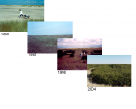
Woody expansion has been documented for years in many different systems, often the result of anthropogenic changes in the environment (e.g., grazing pressures, fire suppression). The VCR islands exist in a relatively natural state with very little anthropogenic inputs, making them ideal for studying climate change effects. Long-term monitoring at the VCR show that the dominant native shrub, Myrica cerifera, has been expanding into grasslands on all islands that have not declined in area since 1973 (Figure 1). These shrub thickets represent stable portions of the barrier island landscape, and can be used as indicators of vulnerability in coastal systems since they are sensitive to salinity, flooding, and drought stress. They serve as sensitive sentinels of global climate change and long-term monitoring may reveal tipping points for ecological processes, especially shifts in species distributions, prior to detection in more inland systems.
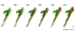
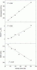
In one study (which is soon to be published in Geocarto International), VCR scientists and graduate students used historical satellite imagery to investigate the conversion of land on a Virginia barrier island over 30 years, and examined several climatic factors that could help explain the expansion of woody vegetation. This study revealed that while the upland area of Hog Island has fluctuated over the timeframe, overall there has been little net change, but woody vegetation increased 285% (Figure 2). Successional processes alone could not account for this rapid increase. Rather, strong relationships were observed between woody cover and decreases in winter minimum temperatures, precipitation, and increasing atmospheric carbon dioxide (Figure 3). Moreover, woody expansion was noted in many areas of the island that had been stable for at least 30 years.
Considering the latitudinal position of the Virginia barrier islands, this barrier system may be especially sensitive to climate change effects. The wax myrtle (Myrica cerifera), for example, typically grows near the northern edge of its distribution and recent expansion across all islands may indicate a shift in its distributional range. This occurrence has been observed for other species as well, including the dune building grass (Uniola paniculata), which has expanded the northern range of its distribution and successfully established on the southern Virginia barrier islands. With such a significant increase in woody vegetation, biogeochemical changes are expected, especially increases in carbon sequestration and soil nitrogen since Myrica is an actinorhizal nitrogen fixer.
According to Don Young, an LTER scientist who has worked at the VCR on terrestrial vegetation processes, the conversion of grassy swale to thicket has been astonishing, especially considering that Myrica is a native species. “Over the past 22 years I have seen a dramatic increase in shrub cover on Hog Island,” he says. “Using existing ground based data collected over this time interval in conjunction with a diverse array of remotely sensed imagery may help us understand large-scale historical ecological changes across the VCR island landscapes.”
Analysis of recent LiDAR (Light Detection And Ranging) data acquired by the VCR showed that Myrica has so far expanded into only 50% of its preferred habitat (based on elevation and distance to shoreline), leaving room for further expansion. For the Virginia barrier system, these woody communities can serve both as negative and positive sentinels of climate change. Loss of woody vegetation will indicate eroding shorelines or topography not keeping pace with rising sea-level, resulting in stress due to saltwater intrusion. However, we are currently witnessing the positive responses as distributions expand due to associated atmospheric effects of climate change, resulting in stability in these times of uncertain change across the Virginia barrier landscape.
Note: The article, “Woody vegetative cover dynamics in response to recent climate change on an Atlantic coast barrier island: a remote sensing approach” is due to be published in a special issue entitled “Remote Sensing of Barrier Island Dynamics” in Geocarto International, December 2011.
 Enlarge this image